One of the primary uses of GNSS systems such as GPS is to help people navigate as they travel about the Earth. As with celestial navigation, GNSS enables us to find our position in unknown territories.
With suitable means of communications, GNSS functionality can also be extended to track people. Combining tracking techniques with geographical maps creates the possibility of providing guidance information to assist people in their movements, as is widely done for car navigation and safety-critical applications in support of aircraft, trains, and marine vessels.
In contrast to motorized vehicles, however, a large part of pedestrian movement takes place indoors or in light indoor environments. (These environments describe areas where the surrounding construction/vegetation block GNSS satellite signals to a greater or lesser extent. Urban canyons, sport stadiums, or a building entrance made of glass illustrate light indoors.)
For example, in the course of a single day a mobile maintenance worker receives new service requests and visits the associated area with his car. The worker spends the major part of his day repairing hardware inside buildings where he often needs navigation data in an unfamiliar environment. Moreover, he has an additional interest in any safety improvement that arises from his ability to navigate and be tracked on his work sites.
In the outdoors, where there is a clear line of sight to the satellites, GNSS technology is able to provide location with good accuracy and continuity of service. However, indoor and light indoor environments are quite challenging for satellite positioning and alternate navigation methods need to be sought that better suit these scenarios. The use of assisted-GPS (AGPS) and inertial navigation systems (INS) can be considered as two of these alternate methods.
AGPS techniques use data disseminated by a telecommunication channel to a GPS receiver in order to improve the receiver’s sensitivity, reduce its time-to-fix, and minimize the complexity of its design. The techniques typically involve a mobile phone able to acquire GPS signals, a cellular network, and an assistance data server.
AGPS enlarges the working area of a stand-alone GPS receiver to urban canyons or even indoors, where large signal attenuation and degradation effects worsen receiver performance. However the recent success of AGPS must not hide its technical limitations. In these challenging environments, signal strength might be too low even for AGPS.
Even with sufficient signal strength, a high probability of acquiring only reflected (multipath) or cross-correlation signals introduces significant errors into the GPS measurements. Such situations highlight the need for complementary technology for reliable indoor navigation or tracking. This article describes development of a pedestrian navigation system based on inertial sensors and an assisted GNSS receiver, using a loosely coupled scheme.
Inertial MEMS
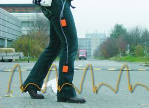
Inertial sensors used in pedestrian navigation typically use micro-electromechanical system (MEMS) designs. MEMS result from the integration of mechanical elements on a common silicon substrate through micro-fabrication technology. They were not specifically developed for positioning, but they offer great possibilities for indoor and outdoor navigation in an autonomous and independent manner.
One of the first localization processes, largely based on step detection and identification algorithms, was developed at the Ecole Polytechnique Fédérale de Lausanne (EPFL). (See the article by Quentin Ladetto cited in the Additional Resources section at the end of this article.). Pedestrian navigation based on MEMS sensors is affected by large amounts of drift and noise, typical of these sensors. These factors introduce errors into the estimation of displacement and azimuth.
We can reduce the effect of these errors by exploiting the biomechanical and physical characteristics of the human stride, but also by hybridizing MEMS information with absolute position information provided from other sources. The need for hybridization is also dictated by the fact that MEMS-based algorithms provide only relative data from the previous position solution to the current one. We need to use absolute positioning data, such as AGPS, to relocate or reinitialize the MEMS-based walking path in an absolute geographical reference frame.
The coupling of different navigation systems is an efficient way to improve positioning performances. The technique consists of combining measurements from complementary navigation devices to yield a hybridized system with increased accuracy, availability, and robustness. Pedestrian navigation based on MEMS and AGPS offer non-correlated complementary features that present them themselves as good candidates for a hybridization scheme.
This coupling scheme has been studied mainly in transition phases from outdoors to indoors and the opposite. We can also consider it in a broader sense as a hybridization algorithm of MEMS-based positioning combined with data from any absolute positioning system.
The research presented in this article has been mainly carried out in the framework of the European project LIAISON (LocatIon bAsed servIceS for the enhancement of the wOrking enviroNment) in which EPFL participates. The global objective of this research is to cope with the kind of positioning errors described previously and to improve pedestrian navigation solutions mainly for emergency interventions.
LIAISON intends to facilitate the work of isolated workers, such as firefighters or taxi drivers, by providing them a mobile location device. The results of LIAISON will help forward the entry of Europe in the regulations such as the E112 standard. The project, which is coordinated by Alcatel Alenia Space, officially began in September 2004 with a planned duration of 42 months.
. . .
Conclusions
The extended Kalman filter and the enhancements presented earlier show interesting improvements for outdoors/indoors transition scenarios, compared to existing loosely coupled schemes. The main achievements result in an improved accuracy and reliability. Thanks to the distributed MEMS sensors configuration, the tracking of the movements of a person is also more precise. The filter is able to output accurate quasi-instantaneous data that are useful for safety applications.
Being able to identify the time a person is entering a zone where AGPS data are not reliable remains a difficult task. The deterioration of AGPS is often correlated with surrounding obstacles. The provision of additional data that indicated if the pedestrian is still outdoors or has just gone indoors could improve the” filter performances.
Without thinking about more complex techniques, such as match-mapping, for example, it certainly would be interesting to try to improve the hybridization process by incorporating data on the number of satellites tracked and their signal-to-noise ratio in addition to the existing 3GPP location format.
Acknowledgements
We are thankful to Kamiar Aminian and Bijan Najafi from the EFPL Laboratory of Movements Analysis and Measurements for their collaboration.
(For the rest of this story, please download the complete article using the PDF link above.)


