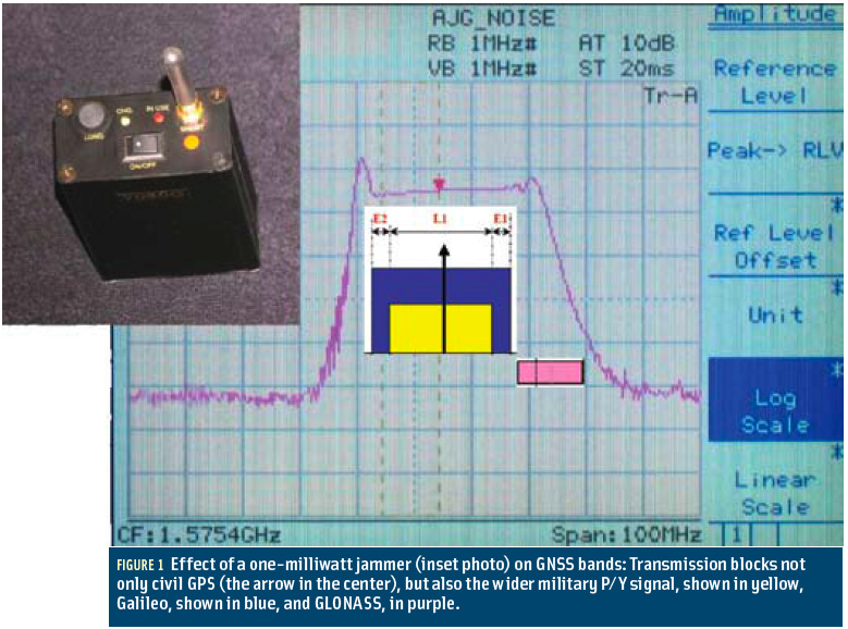
GNSS & the Law Archives - Page 24 of 26 - Inside GNSS - Global Navigation Satellite Systems Engineering, Policy, and Design

GNSS & the Law

May 19, 2011

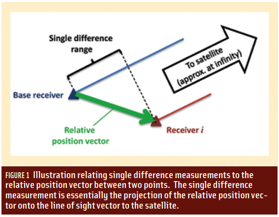
How do you compute relative position using GNSS?

Figure 1

Q: How do you compute relative positions with GNSS?

A: GNSS is well recognized as an excellent means of computing position, but many people think that GPS only provides absolute position information. However, GNSS can also provide relative position information. In this column, we will look at some of the details of how this is done.

Read More >

By Inside GNSS

Homeland Security Steps Up to Protect GPS (But Not from LightSquared)

After a long series of fits and starts, the Department of Homeland Security is tackling the issue of interference to the GPS signal. The agency has launched a study to assess the risks to GPS service from a variety of sources — a study that, at least on paper, will lead to a plan to mitigate interference.

Unfortunately, the effort will not directly address the one potential problem consuming the thoughts of the GPS community — widespread receiver overload from the high-powered mobile broadband service proposed by the Virginia firm LightSquared.

Read More >

By Dee Ann Divis
[uam_ad id="183541"]
March 23, 2011

GNSS Hotspots | March 2011

One of 12 magnetograms recorded at Greenwich Observatory during the Great Geomagnetic Storm of 1859
1996 soccer game in the Midwest, (Rick Dikeman image)
Nouméa ground station after the flood
A pencil and a coffee cup show the size of NASA’s teeny tiny PhoneSat
Bonus Hotspot: Naro Tartaruga AUV
Pacific lamprey spawning (photo by Jeremy Monroe, Fresh Waters Illustrated)
“Return of the Bucentaurn to the Molo on Ascension Day”, by (Giovanni Antonio Canal) Canaletto
The U.S. Naval Observatory Alternate Master Clock at 2nd Space Operations Squadron, Schriever AFB in Colorado. This photo was taken in January, 2006 during the addition of a leap second. The USNO master clocks control GPS timing. They are accurate to within one second every 20 million years (Satellites are so picky! Humans, on the other hand, just want to know if we’re too late for lunch) USAF photo by A1C Jason Ridder.
Detail of Compass/ BeiDou2 system diagram
Hotspot 6: Beluga A300 600ST

1. NORTHERN LIGHTS
Northern Hemisphere

√ The sun has been in a feisty mood lately, with solar flares mid-February to mid-March. GNSS signals haven’t been affected, because these plasma ejections have magnetic fields that are parallel to Earth, instead of perpendicular to it. That could change suddenly, according to the Space Weather Prediction Center. (Meanwhile, the Northern Hemisphere has enjoyed brilliant auroras.)

Read More >

By Inside GNSS
March 21, 2011

Can You Hear Us Now?

Most of us who have ever gotten onto an airplane know the drill: when the doors are closed and sealed and the pilots push back from the terminal, the mobile phones are turned off — along with other portable electronic devices.

There’s a reason for that. Airline operators and the Federal Aviation Administration wish to avoid any possible interference with the aircraft’s avionics that support its navigation and communications functions.

Read More >

By Dee Ann Divis
March 14, 2011

GNSS Receiver Clocks

Q: Does the magnitude of the GNSS receiver clock offset matter?

A: It is well known that GNSS receiver clocks drift relative to the stable atomic time scale that ultimately defines a particular GNSS system in the first place. GNSS receiver manufacturers, however, try to limit the magnitude of the time offset to within some predefined range.

Read More >

By Inside GNSS

Integer Aperture Estimation

For the complete story, including figures, graphs, and images, please download the PDF of the article, above.

Integer carrier-phase ambiguity resolution is the key to fast and high-precision GNSS positioning and navigation. It is the process of resolving the unknown cycle ambiguities of the carrier-phase data as integers. Once this has been done successfully, the very precise carrier-phase data will act as pseudorange data, thus making very precise positioning and navigation possible.

Read More >

By Inside GNSS
[uam_ad id="183541"]
January 24, 2011

GNSS Hotspots | January 2011

One of 12 magnetograms recorded at Greenwich Observatory during the Great Geomagnetic Storm of 1859
1996 soccer game in the Midwest, (Rick Dikeman image)
Nouméa ground station after the flood
A pencil and a coffee cup show the size of NASA’s teeny tiny PhoneSat
Bonus Hotspot: Naro Tartaruga AUV
Pacific lamprey spawning (photo by Jeremy Monroe, Fresh Waters Illustrated)
“Return of the Bucentaurn to the Molo on Ascension Day”, by (Giovanni Antonio Canal) Canaletto
The U.S. Naval Observatory Alternate Master Clock at 2nd Space Operations Squadron, Schriever AFB in Colorado. This photo was taken in January, 2006 during the addition of a leap second. The USNO master clocks control GPS timing. They are accurate to within one second every 20 million years (Satellites are so picky! Humans, on the other hand, just want to know if we’re too late for lunch) USAF photo by A1C Jason Ridder.
Detail of Compass/ BeiDou2 system diagram
Hotspot 6: Beluga A300 600ST

1. HAPPY BIRTHDAY!
Los Angeles, California USA
√ Congratulations to SVN 23, a GPS IIA satellite, for 20 glorious years. The GPS Directorate expects 12–18 months more of active duty from the overachieving space vehicle, which was expected to last only 7½ years. (Meanwhile, Europe’s first Galileo test satellite, GIOVE-A, was expected to last 27 months and is still cookin’ after five years.)

Read More >

By Inside GNSS
January 21, 2011

Your Signal Is My Noise

Most people probably don’t associate engineers and linguistic virtuosity.

The attitude is unfair, of course, as with so many stereotypes.

And also untrue.

For example, as the number of existing or planned GNSS systems grew during the past few years, the expression “Your signal is my noise” has recurred in the engineering community with increasing frequency.

I consider that an elegant, if ominous, turn of phrase. A simple declarative sentence, pithy, with an ironic edge, yet almost lyrical.

Read More >

By Inside GNSS
January 9, 2011

Differences between Signal Acquisition and Tracking

Q: Why is acquisition of GNSS signals generally more difficult than tracking and what are the limiting factors?

A: A fairly good analogy of the difference between GNSS signal acquisition and tracking can be found in the rescue of victims of a sunken ship whose location is not accurately known. The first stage of the rescue attempt typically involves an aircraft flying a search pattern, which hopefully encompasses the location where the ship went down.

Read More >

By Inside GNSS

Wavelets and Notch Filtering

FIGURE 1: Touching wavelet spectra

For the complete story, including figures, graphs, and images, please download the PDF of the article, above.

The use of GNSS for safety critical applications is gaining interest, particularly amongst aviation users, who probably have the most demanding requirements. The GNSS frequency band containing the Galileo E5 and GPS L5 signals is designated as an aeronautical radio navigation service (ARNS) band, which enjoys legal protection from other services not allocated to this frequency on a primary basis.

Read More >

By Inside GNSS
December 2, 2010

GNSS Hotspots | December 2010

One of 12 magnetograms recorded at Greenwich Observatory during the Great Geomagnetic Storm of 1859
1996 soccer game in the Midwest, (Rick Dikeman image)
Nouméa ground station after the flood
A pencil and a coffee cup show the size of NASA’s teeny tiny PhoneSat
Bonus Hotspot: Naro Tartaruga AUV
Pacific lamprey spawning (photo by Jeremy Monroe, Fresh Waters Illustrated)
“Return of the Bucentaurn to the Molo on Ascension Day”, by (Giovanni Antonio Canal) Canaletto
The U.S. Naval Observatory Alternate Master Clock at 2nd Space Operations Squadron, Schriever AFB in Colorado. This photo was taken in January, 2006 during the addition of a leap second. The USNO master clocks control GPS timing. They are accurate to within one second every 20 million years (Satellites are so picky! Humans, on the other hand, just want to know if we’re too late for lunch) USAF photo by A1C Jason Ridder.
Detail of Compass/ BeiDou2 system diagram
Hotspot 6: Beluga A300 600ST

1. STORMY WEATHER
Belgium and Brazil

Read More >

By Inside GNSS
IGM_e-news_subscribe