
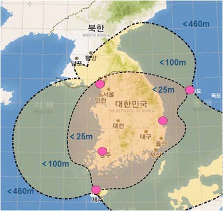
 Projected accuracy and coverage of Korea’s eLoran network. Ministry of Oceans and Fisheries of Korea
GPS jamming attacks from North Korea that have increased in frequency and duration since they began August 2010 have prompted the South Korean government to implement an enhanced Loran (eLoran) systems that will cover the entire country by 2016.
The South Korean government completed design, development, and construction documents for the eLoran system in February and will procure the system infrastructure through international competitive bidding.
Plans for the alternative and backup system were described for the first time at an international forum in a paper presented yesterday (April 23, 2013) at the European Navigation Conference (ENC) in Vienna, Austria.
Authors of the paper are Jiwon Seo, an assistant professor in the School of Integrated Technology at Korea’s Yonsei University who is working closely with the Ministry of Oceans and Fisheries of Korea to design and implement the eLoran system, and Mincheol Kim, a deputy director of the Maritime Safety Facilities Division in the Ministry of Oceans and Fisheries who is in charge of the Korean eLoran program.
Last year, 1,016 airplanes and 254 ships in South Korea experienced GPS disruptions during 16 days of North Korean jamming, according to Seo and Kim. The frequency and duration of North Korean GPS jamming have continuously increased from four days in 2010.
The goal of the Korean eLoran system is to provide better than 20-meter positioning and navigation accuracy over the country. Initial operational capability (IOC) is expected in 2016 with final operational capability (FOC) is expected in 2018.
The South Korean government hopes to expand eLoran coverage to the entire Northeast Asia in close collaboration with Russia and China in the near future.
The Korean eLoran system is expected to satisfy the accuracy, availability, continuity, and integrity requirements of the harbor entrance and approach (HEA) for marine vessels and non-precision approach (NPA) for aircraft.
The eLoran system will be procured through International Competitive Bidding (ICB). Enhanced Loran improves upon previous Loran systems by using updated equipment, signals, and operating procedures. These changes allow eLoran to provide better performance and additional services when compared to Loran-C.
Research into jamming during 2011 conducted by the Electronics and Telecommunications Research Institute (ETRI) of South Korea indicated that the L1, L2, and L5 bands were all affected. ETRI observed high-power continuous wave (CW) jamming signals in the L1 band. For L2 and L5 bands, multiple CW-type jammers swept the whole bands by moving their center frequencies.
Researchers also noticed that North Korea seemed to be experimenting with their jammers by operating at various transmission powers, frequencies, and jamming intervals.
South Korea has two legacy Loran-C stations in Pohang and Kwangju. These will be converted into eLoran stations in 2014. In addition, three new eLoran stations would be built in Ulleung, Ganghwa, and Jeju on sites to be acquired this year. The five stations will be able to provide radio navigation service over all of South Korea, Seo and Kim said.
For differential eLoran service, 43 differential eLoran stations will be deployed over the country, some of them collocated at existing differential GPS stations. Testing of the system will be carried out during 2016 and 2017, leading to a declaration of FOC in 2018.
Because eLoran signals propagate differently over land and seawater (where it slows due to lower conductivity), corrections to the signal delay referred to as additional secondary factors (ASF) must be incorporated into the system. The Korean eLoran system will prepare ASF maps with a dense grid size for land areas to mitigate related spatial errors.
The Korean government’s announcement contrasts with the U.S. decision in 2010 to discontinue its Loran-C system despite an independent review team’s unanimous recommendation that it be upgraded to eLoran as a backup to GPS and other national positioning, navigation, and timing (PNT) technologies.
The United Kingdom has also pushed ahead with eLoran, launching an initial service in the English Channel earlier this year.


