
Representatives from the world’s GNSS system and augmentation providers spent a sun-laden week in Pasadena, California, recently, advancing aspirations for their separate enterprises while refining the basis for compatibility and interoperability among them.
Representatives from the world’s GNSS system and augmentation providers spent a sun-laden week in Pasadena, California, recently, advancing aspirations for their separate enterprises while refining the basis for compatibility and interoperability among them.
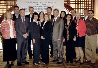
The occasion was the third meeting of the International Committee on GNSS (ICG-3), a voluntary United Nations–backed association that brings together GNSS and augmentation providers — including the United States, Russia, European Union, China, India, and Japan —associate members representing key user communities.
After its formal launch in December 2006, the ICG sketched out a bold vision of cooperation and shared principles in joint statements of the committee and a Providers Forum during the group’s second meeting in Bangalore, India, in September 2007.
The third meeting in Pasadena, however, reflected a more cautious approach by most members as they began collectively translating general principles into work plans that could lay the foundation for technically and operationally aligned systems — without undercutting separate and frequently divergent goals for individual GNSSs.
As one American delegate observed in an aside comparing the India and U.S. meetings: “Four steps forward and one step backward.”
Nonetheless, the conference did mark new advances in the ICG project. For the first time, the Providers Forum adopted a Terms of Reference and a work plan. The ICG plenary also agreed that the Regional Centres for Space Science and Technology Education, affiliated with the United Nations, would act as ICG Information Centres in the future. The ICG further agreed to establish a Task Force on Geodetic References and a Task Force on Time References to consider improvements based on closer alignments of those key parameters.
Hosted by the United States, the meeting was chaired by Ken Hodgkins, director of the U.S. State Department’s Office of Space & Advanced Technology, with local arrangements taken care of by the Jet Propulsion Laboratory (JPL), California Institute of Technology, and the offices of the International GNSS Service (IGS) Central Bureau located at JPL.
The UN Office for Outer Space Affairs (OOSA) represented by Sharafat Gadimova, an OOSA program officer, serves as executive secretariat for the ICG. Copies of the presentations given at the meeting can be downloaded from the OOSA website.
Appeal Toward "Interchangeability"
At ICG-3, Brad Parkinson, a Stanford University professor emeritus and the original manager of the GPS Joint Program Office in the 1970s, set the tone for the meeting in the opening plenary with an appeal for collaborative efforts that would move beyond interoperability to “interchangeability.” This concept, which allow use of “any four [GNSS satellites] anytime,” requires a closer alignment of GNSS system time and coordinate reference systems than currently proposed, Parkinson said.
Parkinson, who is vice-chair of the advisory committee to the U.S Space-Based Positioning, Navigation, and Timing (PNT) Executive Committee, also called for high-level support of earlier delivery of GPS III satellites, currently scheduled for 2014, and a more robust constellation of 30 space vehicles (SVs) in 30 orbital slots, plus spares.
His comments echoed a growing concern at the possibility of “GPS brownouts” if a substantial number of GPS spacecraft failed at the same time, creating holes in the coverage until new generations of satellites can be brought online.
STATUS REPORTS
GLONASS and Compass
Program updates revealed steady progress by Russia, with a delegation was headed by Yury Nosenko (deputy director of the Russian Space Agency or Roscosmos), which expects to have 24 GLONASS satellites or space vehicles (SVs) on orbit by the end of 2009. Meanwhile, China, announced plans to launch 3 to 4 Compass (Beidou 2) spacecraft in 2009 and 11 over the next two years.
Sergey Revnivykh, director of the Satellite Navigation Department in the Roscosmos Mission Control Center, noted that flight test of the first GLONASS-K satellite toward the end of 2010 will allow Russia to evaluate new CDMA signals that it plans to broadcast at L1 and possibly L3 frequencies. GLONASS will continue transmitting its existing FDMA signals for the “unlimited future” to provide backward compatibility, Revnivykh added.
Jun Lu, representing the China Satellite Navigation Project Center, said that results from 18 months of observations of the first Compass middle earth orbiting (MEO) satellite launch in April 2007 indicated a precise orbit determination of better than 5 meters as well as the ability to predict future orbits of better than 10 meters over a 24-hour period.
The four rubidium atomic frequency standards on board the MEO-1 spacecraft are providing a synchronization with Compass system time of about two nanoseconds, she said.
GPS
Presentations by U.S. representatives focused on recent publication of new performance standards, progress in U.S. space- and ground-based augmentation systems, and GPS interference detection and mitigation. They also described GPS modernization plans scheduled to bring fully operational capability (FOC) with 24 GPS SVs broadcasting the second civil signal (L2C) by 2016, L5 by 2018, and the new L1 civil signal by 2021.
U.S. presenters included Mike Shaw, director of the National Coordination Office for Space-based PNT, Leo Eldredge, GNSS program director at the Federal Aviation Administration, Col. David Goldstein, chief engineer for the GPS Wing at Los Angeles Air Force Base, and John Merrill, with the Office of Applied technology, Geospatial Management Office, in the Department of Homeland Security. Lt. Col. Patrick Harrington, from the Office of the Under Secretary of the Air Force Directorate of Space Acquisition, headed the U.S. delegation.
Galileo
Paul Verhoef, head of the Galileo unit for the European Commission Directorate-General for Transport and Energy, said that the EU expects to have contracts for building the Galileo FOC system in place by next summer. He noted that the target date for completion is 2013 had been given to prospective vendors in the Galileo invitations to tender (ITTs). “We’ll see if and how they will make it.”
The European GNSS Supervisory Agency (GSA), which had been charged with overseeing development and operation of Galileo under the abandoned public-private partnership, will be given a different name next year to reflect its altered responsibilities under the public procurement now led by the EC and the European Space Agency. Verhoef added that about 30 GSA staff members will soon be transferred to the EC’s Galileo unit.
Meanwhile, despite pointed industry encouragement, Verhoef gave no further indication on when a final interface control document (ICD) will be available so that manufacturers know the commercial terms and technical specifications for building and selling Galileo-capable equipment.
GAGAN
The Indian government has approved the follow-on plan for its satellite-based augmentation system — the GPS Aided, Geo Augmented Navigation (GAGAN, which stands for “space” in Sanskrit). It plans to launch the first payload on its GSAT-4 satellite next April or May and a second GAGAN payload on GSAT-8 in the last quarter of 2009, according toSuresh Kibe, satellite navigation program manager at the Indian Space Research Organization (ISRO). A third GAGAN GEO is scheduled for launch on GSAT-9 or -10 in 2010.
Kibe says development continues for the Indian Regional Navigation Satellite System (IRNSS), with seven to nine satellites (in both geosynchronous and non-geosynchronous orbits). It will include an open standard positioning service (1Mhz, biphase skip keying signal) and a restricted service — BOC (5,2) signal — at 1176.45 MHz (L-band) and 2492.08 MHz (S-band).
India is studying the signal structures of GPS L2C, L5, and L1C as the basis for the IRNSS signal design.
QZSS
The Japan Aerospace Exploration Agency (JAXA) will launch the first satellite in its Quasi-Zenith Satellite System (QZSS) in the summer of 2010, followed by a year of in-orbit validation. Although QZSS will include several open signals closely aligned with GPS, two additional signals — an L1-SAIF (submeter-class augmentation with integrity function) and an experimental signal (LEX) at 1278.75 MHz — may be implemented with fees charged by a private operator, according to Koji Terada, QZSS program manager for JAXA.
WHAT’S NEXT
Convergence or Divergence?
The pressures to advance individual programs create centrifugal forces that threaten to overcome the centripetal impulse represented by the ICG.
GNSS providers are acutely aware that GNSS represent critical infrastructures that can reinforce a nation’s political leadership at the global level. At the same time, however, GNSS supports commercial industries and markets that continue to grow steadily even in the current economically challenged conditions.
Participating in those markets requires an essential compatibility with a common technical standard — now represented in an ad hoc way by GPS, but likely to expand into a more generic form as the other systems are completed.
The presence of user communities and industry representatives at ICG-3, many as invited speakers, underscored the pressures that government officials are feeling to ensure that individual GNSSs remain part of the mix incorporated into manufacturers’ designs.
Divergent tendencies also reflect different priorities currently existing among the GNSS programs, which might be summarized as follows:
The United States: maintaining its lead as the first and only fully operational GNSS while ensuring open civil standards and a “level playing field” in international trade in GNSS products and services; providing a multilateral forum where representatives can discuss scientific and technology matters that national policy prevents them from addressing bilaterally (i.e., with China).
EU: fostering the growth of European high-tech expertise while preserving its options for managing the system and still maintaining momentum to implement Galileo as globally competitive GNSS; convincing China to move off of portions of radio spectrum where Galileo’s security-oriented public regulated service (PR) will operate (not necessarily in that order).
Russia: Increasing the appeal of GLONASS to consumer manufacturers and markets and establishing ground monitoring facilities outside the Russian territory; developing its industrial base to produce domestically designed equipment for military and commercial applications.
China: Bringing its system online quickly for national security and commercially competitive reasons, capturing global mass markets for Chinese-built goods, and establishing Compass as the world’s preeminent GNSS system.
Making GNSSs Compatible and Interoperable
The most intense discussions at ICG-3 revolved around the Providers Forum terms of reference, work plan, and “working principles of compatibility and interoperability and their further definition.” Taking place in open sessions of the ICG’s four working groups and closed Providers Forum meeting, delegates ground through wording of the documents in a process of language arts commonly likened to “sausage-making.”
The process was probably more revealing than the results, which can be viewed in the official report issued following the meeting. A copy of the report can be downloaded as a PDF at the end of this article.
The nuances reflected underlying issues between individual GNSS providers, including some under discussion in bilateral talks and others have yet to be raised. These issues China’s plan to transmit Compass signals on the same frequencies as Galileo’s Public Regulated Service (PRS) and GLONASS’s possible selection of a BOC (2,2) design for its CDMA signal at L1.
As an example of the tendency toward divergence, consider the various approaches to defining compatibility and interoperability taken up by Working Group A charged with drafting appropriate language on the subject for the ICG workplan.
Barriers to "interoperability"?
At the Bangalore meeting, wording for the compatibility principle suggested that “Compatibility should also involve spectral separation between each system’s authorized service signals and other systems’ signals. ” However, in Pasadena several representatives pointed out that spectral overlap already exists in signals for a number of authorized or restricted services.
Ultimately, the group agreed on the following language: “Compatibility should also respect spectral separation between each system’s authorized service signals and other systems’ signals. Recognizing that some signal overlap may be unavoidable, discussions among providers concerned will establish the framework for determining a mutually acceptable solution.”
Interoperability posed an even more complex challenge for reconciliation. Although European and Indian delegations remained satisfied with the language worked out in Bangalore, the intervening months appear to have brought second thoughts and diverging analyses by other providers.
In a U.S. effort to flesh out the concept, Harrington presented a lengthy set of technical characteristics that he suggested underlie interoperability. These included common time and reference frames or broadcast of the offsets between systems, common carrier frequencies, similar spreading modulation spectra, common minimum and maximum power levels, common spreading code lengths and common code family, and common data message structure and encoding.
Professor Grigory Stupak of the Russian Institute for Space Device Engineering (RISDE) introduced a formula in which interoperability could be quantified usingother criteria for cost (price, size, weight, power consumption) and performance (accuracy, availability, reliability, responsiveness).
China first proposed that interoperability simply “allows navigation with signals from different systems with minimal additional receiver cost or complexity.”
Eventually, the working group agreed that, in addition to the Chinese description, for purposes of interoperability, “Geodetic reference frames realization and system time steerage standards should adhere to existing international standards to the maximum extent practical.” The ICG-3 language also acknowledged the benefits of multiple constellation in providing improved accuracy and availability of PNT services.
In the preface to the revised document, delegates added, “For many applications, common carrier frequencies are essential to interoperability, and commonality of other signal characteristics is desirable. In some cases, carrier frequency diversity may be preferable to improve performance.”
The workplan also included language that providers should develop “proposals to widely monitor the performance of their open signals and provide timely updates to users” with a “focus on potential cooperation in the development of the necessary ground infrastructure to monitor signal and service performance for open services. . . .”
Finding an Appropriate Forum
Another point of contention revolves around the role of the International Telecommunications Union (ITU), a UN-affiliated body that allocates radio spectrum in world radiocommunication conferences for particular uses regionally and globally. Compliance is voluntary, but generally effective among ITU members.
However, the ITU is essentially limited to addressing a narrow definition of compatibility, based on frequency allocations and attempts to limit cumulative increases in the RF noise floor within radio bands as a result of new systems and signals. Adding signals can eventually create interference to existing services within a frequency allocation.
China appears inclined to rely more heavily upon the ITU process, while others are less sanguine about the organization’s capability for reconciling broader differences among programs.
Among these differences is the matter of spectral separation of military or authorized services, such as the GPS M-code and Galileo PRS, which have been the subject of a series of bilateral talks — thus far inconclusive — between China and the United States and the European Union in recent years.
Apparently, the Chinese have acknowledged GPS as a legacy system that has a well-established presence in certain bands and will avoid conflicts with it. However, they consider Galileo, as a system at a comparable stage of development with Compass and, therefore, with comparable claims to the spectrum. The launch of the first Compass MEO in April 2007 provided a foothold, a claim that they could well expand with the additional launches of satellites over the next two years.
Reportedly, China has posed a long list of requirements to EU negotiators, including some unrelated to GNSS, as conditions for abandoning or reducing their frequency plans for Compass.
The ICG itself has yet to demonstrate whether it will tangibly and practically improve the prospects for creating a global GNSS system of systems with true compatibility and interoperability among separate GNSSs. Or whether it is merely a debating society or paper tiger, as some have suggested.
But for the time being, the ICG appears to offer the only alternative to continuing rounds of bilateral negotiations that may achieve individual agreements but may have less success in coordinating uniformity among GNSS providers. If nothing else, the ICG offers a more open forum in which moral suasion compels a semblance of cooperation.
ICG-4 in St. Petersburg
The next conference, ICG-4, is scheduled for September 14–18, 2009 in St. Petersburg, Russia. ICG-4 planning meetings will take place next February and June during OOSA meetings in Vienna.
* * * * * * * *
Note: Inside GNSS editor Glen Gibbons was invited to address the ICG-3 on December 9. His comments can be seen here.


