• LightSquared first report to FCC (PDF)
• LightSquared first report to FCC (PDF)
Yesterday (March 15, 2011), a working group mandated by the FCC waiver to address the potential LightSquared/GPS interference issue delivered its first monthly report required by the FCC.
The report lists the 34 members of a key technical working group (TWG) that will support the overall working group’s efforts to assess the risk for GNSS receivers operating under conditions of a dense national network of high-powered cell phone transmitters. The TWC has almost double the number of expected members proposed in a February 26 agreement, including a long list of prominent GPS experts from industry, wireless providers, engineering firms, public safety and various federal agencies.
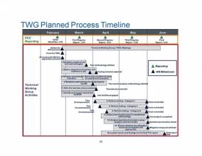
The first report describes the groups progress on seven items:
1. Establish pertinent analytical and test methodologies and assumptions underlying the test regime: definition of harmful interference, relevant information regarding terrestrial broadband network, interference analysis assumptions, and evaluation of potential test methodologies
2. Select categories of receivers and receivers to be tested
3. Develop operational scenarios
4. Establish methodology for analyzing test results
5. Derive test conditions based on the established operational scenarios
6. Write test plan and procedures
7. Identify and engage appropriate test facilities.
The TWG met initially on March 3 and has held several teleconference since then. LightSquared provided technical details to the TWG regarding the equipment that is planned for its terrestrial broadband deployment includes the channelization plan, output power, out-of-band emission (OOBE) characteristics and emissions mask.
As described in the working group report, the GPS community is concerned that desensitization/overload due to strong signals outside of the GPS band may cause GPS receivers to operate in a non-linear mode with reduced gain (i.e., gain compression) for the desired GPS signal. Other receiver impairments may also arise as a result of the by nearby strong signals.
The TWG has agreed to move forward with a combination of laboratory-based and field-based testing programs. Field testing will be performed at outdoor test locations using transmitters, filters, and antennas similar to those that LightSquared plans to deploy in its commercial operations.
Due to the heightened concern about interference occurring during its test operations, especially for aviation applications, LightSquared says it will work closely with the Federal Aviation Administration (FAA) in the test site selection process so that the FAA may issue Notices to Airmen (NOTAMs) should the agency determine it is appropriate.
The TWG has identified seven categories of receivers that it considers representative of non-military GPS user equipment operating in the United States: aviation, cellular, general location/navigation, high precision, timing, space-based receivers, and networks.
Public safety receivers are included in precision timing and in general location/navigation. Receivers used in science are included in high precision. Commercial and global maritime distress and safety receivers are included in general location/navigation.
The TWG has created seven sub-teams, each focused on one of these receiver categories. These sub-teams are responsible for determining device selection and prioritization criteria, defining operational scenarios, listing testing conditions and test plan procedures, and recommending appropriate test facilities.
The Technical Working Group members are:
Co-chairs
Jeffrey Carlisle, LightSquared, Executive Vice President for Regulatory Affairs and Public Policy
Charles Trimble, Chairman of the United States GPS Industry Council (USGIC), principal founder and former president, CEO, and a director of Trimble Navigation Limited
Members
Dominick Arcuri, senior vice-president, RCC Consultants, Inc., in charge of Public Safety Radio Communications
Knute Berstis, engineer, National Geodetic Survey (detailed to National Coordination Office for Space-Based Positioning, Navigation, and Timing)
John Betz, a Fellow of the MITRE Corporation and co-designer of several modernized GPS signal
Michael Biggs, senior engineer, Federal Aviation Administration’s Air Traffic Organization Spectrum Engineering Services
Scott Burgett, software engineering manager, Garmin International
Santanu Dutta, senior vice-president of radio access technology and chief engineer, LightSquared
Richard Engelman, director of spectrum resources, Sprint Nextel
Pat Fenton, chief technology officer, NovAtel Inc.
John Foley, software engineering team leader, Garmin International
Paul Galyean, manager of systems engineering, NavCom Technology (division of John Deere)
Anil Hariharan, captain, U.S. Air Force, and chief of GPS spectrum engineering, GPS Directorate
Chris Hegarty, director for CNS engineering & spectrum, MITRE Corporation
Bronson Hokuf, design engineering team leader, Garmin International
Sai Kalyanaraman, senior systems engineer, Rockwell Collins
Jerry Knight, senior product design engineer, NavCom Technology (division of John Deere)
John Lacey, systems engineer, operations manager & lead systems engineer for the Lockheed Martin Regional Positioning System/Geostationary Communications and Control Segment (GCCS)
Farokh Latif, director, Spectrum Management Division of the Association of Public Safety Communications Officials International
Richard Lee, president, Greenwood Telecommunications, which currently consults to LightSquared
Fred Moorefield, technical director and director of strategic planning, Air Force Spectrum Management Office
Tim Murphy, a Technical Fellow and member of the electronic systems organization, Boeing Commercial Airplane
Gary Pasicznyk, manager of Electronic Engineering Bureau of the City & County of Denver, Colorado
Bruce Peetz, vice-president of advanced technology, Trimble Navigation Limited
Brian Poindexter, design engineering manager for consumer automotive products, Garmin International
Tom Powell, systems director, Aerospace Corporation, supporting the Engineering and Technology Branch of the GPS Directorate
Brian Ramsay, a PNT and spectrum policy specialist in NASA’s Space Communications and Navigation program office
Patrick Reddan, senior associate at Zeta Associates who has worked with the FAA WAAS and GCCS Programs
Daniel Reigh, RNSS spectrum issues, Lockheed Martin (company alternate)
Mark Rentz, senior systems engineer, NavCom Technology (division of John Deere)
David Shively, a lead member of technical staff in the Radio Technology Group, AT&T
Mike Simmons, senior RF design engineer at Garmin International
Bill Stone, executive director of network strategy, Verizon Wireless
Mark Sturza, president, 3C Systems Company, consultancy in communications and navigation systems
Greg Turetzky, senior marketing director and distinguished engineer for location strategy, CSR, plc
A.J. Van Dierendonck, consultant to the USGIC, principal at AJ Systems and a partner of GPS Silicon Valley
Rick Walton, navigation services architect/Geostationary Communications and Control Segment program manager, Lockheed Martin (primary company representative)
Larry E. Young, supervisor, group developing high precision GNSS receivers for remote sensing from space, Caltech Jet Propulsion Laboratory
Information Facilitators
Ann Ciganer, vice-president, strategic policy, Trimble, and director, policy, for the United States GPS Industry Council (USGIC)
Martin Harriman, executive vice-president of ecosystem development and satellite business, LightSquared
Geoff Stearn, vice-president of spectrum development, LightSquared
Mike Swiek, executive director, USGIC
The following individuals have offered to serve as advisors to the GPS Working Group:
Bob Calaff, director, spectrum and technology strategy, T-Mobile USA
Mark Cato, senior staff engineer, Air Line Pilots Association
Giselle Creeser, Lockheed Martin
Charles Daniels, senior policy analyst, Overlook Systems Technologies, Inc.
Walter Feller, Hemisphere GPS, Inc.
Alex Gerdenitsch, Motorola Mobility
R. Scott Harris, Florida Permanent Reference Network
Richard Kolacz, president, Global Spatial Technology Solutions
Alfred Leick, professor, University of Maine
Charles Meyer, principal engineer, Alcatel Lucent, Bell Laboratories
Olav Queseth, senior researcher, Ericsson, Inc.
Michael E. Shaw, Lockheed Martin
Claudio Soddu, director of navigation and operational services, Inmarsat Global Limited
Mike Woodmansee, RF engineer, Ericsson, Inc.


