An increasingly urgent call to certify performance of Global Positioning System (GPS) receivers is being heard from several sectors of the national political and business landscape. This issue has arisen now as a direct result of the LightSquared initiative that has generated so much attention over the last 18 months.
Instead of diving into those issues directly, however, a little historical perspective is in order first — and it’s amazing in itself that a technology as new as GPS in the public eye would actually have a history to reflect upon, but it does.
I should emphasize up front that this article is intended to provide a framework for further discussion of GPS receiver compliance with specifications/standards and related certification process models. My comments here will not provide the ultimate answer, but, in light of pending initiatives directed toward better and more efficient utilization of frequency spectrum, they will hopefully add some clarity to the deliberations.
A Historical Perspective
Consideration of commercial GPS receiver certification actually began more than 20 years ago with the formation of the U.S. GPS Industry Council (USGIC). In its inaugural meeting, Council members discussed options for developing a USGIC logo to be affixed to “certified” GPS receivers.
Similar to the Underwriters Laboratory symbol, the logo would serve as a way of establishing a “GPS brand” in international markets and of identifying U.S.-manufactured receivers that had undergone some form of certification testing to validate their performance. The logo was developed, but the cooperative actions necessary to establish an industry-sponsored certification process at that early stage of market development were premature.
In the event, further activity on the receiver certification topic was deferred and quickly overtaken by events as Council member’s attention was diverted by more pressing legislative and regulatory matters. These included the need to respond to and rebuff an initiative by Inmarsat at the 1997 World Radio Conference. This initiative would have encroached on the lower end of the GPS L1 spectrum, the same spectrum that became the focus of the LightSquared controversy.
Another short effort directed toward receiver certification occurred in the mid-1990s, when the Air Force (AF) 746 Test Squadron briefly conducted a voluntary Commercial Receiver Test Program with plans to issue a certification seal confirming performance at or better than the participating manufacturer’s specification numbers. However, for reasons of both timeliness and the legalities associated with certification, the program proved unsatisfactory for industry and unworkable for the Air Force.
At about the same time, institutional changes led to GPS receiver certification discussions taking place on the military side of the fence. Certification had not been an issue for the earliest versions of military GPS receivers, from the 1980s to early 1990s. During that time, virtually the entire family of GPS receivers was procured by the GPS Joint Program Office (JPO) under a “one size fits all” volume-production philosophy (also partly driven by security considerations).
Because the JPO also procured the space (satellites) and ground (control) segments while serving as system integrator, design coordination among the three GPS segments mitigated the need for independent military receiver certification. The advent of security modules in the late 1980s enabled unclassified military receiver operation, and the JPO central procurement role was officially documented in a 1992 Assistant Secretary of Defense (Command, Control, Communications, and Intelligence) policy memorandum.
Later, in the mid 1990s, the AF Wright Avionics Laboratory’s Embedded GPS Inertial (EGI) navigation system became the first major military receiver design procured outside the JPO, and the production of military GPS receivers proliferated widely after that.
As GPS form factors got smaller, opportunities to embed GPS in military systems increased dramatically, and both weapon system program directors and manufacturers chafed under design restrictions that would limit integration options. Consequently, the “one size fits all” philosophy was abandoned. In its place, tailored, system-specific, software-intensive GPS integration designs became the norm.
Acknowledging this institutional evolution, fully in place by the early 2000s, the Assistant Secretary of Defense (Networks and Information Integration) issued new GPS receiver development and procurement policy in 2006 that superseded the 1992 memorandum and assigned the Air Force the responsibility to “develop, implement and maintain GPS Performance Evaluation and Security Certification programs.”
While that policy statement documented a good idea, it did not provide the necessary funding to follow through. The certification process for military receivers had to compete for funding with other GPS military receiver priorities during annual AF and Department of Defense budget debates. Like many other good, but unfunded ideas, receiver certification could not successfully compete for attention without additional motivating factors.
Motivating Factors for Certification
The proliferation of GPS receivers and applications integrated by diverse developers and manufacturers into a wide variety of civil, commercial, and military systems inevitably results in mistakes being made.
We can safely say that virtually all GPS receiver stand-alone and integrated designs are already tested by manufacturers to some extent –— either against their own specifications or specifications levied by customers. Except in the case of avionics equipment, however, where designs are evaluated and certified by the Federal Aviation Administration (FAA), such testing does not necessarily cover all the same operating parameters nor rise to the level of fidelity required for formal “certification.”
Why is that?
GPS signal processing is straightforward, but non-trivial, and some GPS receivers are not fully compliant with all aspects of published Interface Control Documents (ICDs). Consequently, such receivers experience problems when processing GPS satellite signals under non-routine circumstances or if they encounter signal configurations or conditions for which their designers did not account.
This situation can affect both commercial and military receivers and installations, though commercial systems generally experience problems at a higher rate than do military systems. However, all cases of GPS reception problems reported to the Air Force Space Command (AFSPC) GPS Operations Center, whether involving military or commercial equipment, must be quickly and thoroughly evaluated. This is to first rule out problems originating in the GPS satellite constellation or control segment, and only then to home in on the source of the reception problem at the user end.
In most cases, reception issues can be traced to problems in the GPS receiver design or its integration into a positioning, navigation, and timing (PNT) system. Regardless of the cause, each case requires considerable expenditure of time and research effort on the part of AF and contractor personnel.
Let’s consider a specific case in 2010 in which a particular military receiver design was not prepared to handle a signal configuration change uploaded to the satellites by the GPS Control Center. This resulted in temporary operational disruptions for several military weapon systems that had incorporated the receiver, and the anomaly was not resolved until software fixes could be installed. In this case, the non-ICD compliant receiver had been tested by the manufacturer, but not put through the full range of signal conditions that would have uncovered the fault early on.
As a result of this and various other receiver problem experiences, the AF, through the GPS Directorate, began taking a new look at certification process options for military equipment. General Bob Kehler, commander of the Air Force Space Command (AFSPC) requested that the National Space-based PNT Advisory Board “identify a way forward to address the on-going GPS receiver compliance issue.”
That tasking was assigned to the advisory board at its October 2010 meeting. Unfortunately, before much thought could be given to the compliance issue, LightSquared and its proposal to broadcast terrestrial communications services in spectrum adjacent to the GPS L1 signals captured the full attention of government and industry alike.
It is not the purpose of this article to rehash the acrimonious debate that occurred over the LightSquared initiative, other than to note that it focused extensively on the standards and specifications governing GPS signals and on factors affecting the electronic design of GPS receivers.
Follow-on actions for several of the government organizations involved in the LightSquared matter include: 1) consideration of spectrum-related standards for GPS receiver equipment to mitigate performance degradation caused by adjacent band signal transmissions, and 2) processes to verify (“certify”) performance of GPS receivers under all current and anticipated signal structure conditions.
As difficult as the LightSquared controversy has been, it appears to have provided the final motivating factor to elevate GPS receiver certification from the bottom drawer to the desktop.
Compliance with What? Standards & Specifications
Before we look at certification elements and process options in detail, it will help to describe the radio frequency (RF) environment within which GPS is required to operate. In what is called the L1-band, GPS signals are located in RF spectrum allocated by the International Telecommunications Union (ITU) between 1559 MHz and 1610 MHz and designated as Radionavigation Satellite Service (space-to-earth) (RNSS s-e).
GPS signals are centered at 1575.42 MHz and registered in the ITU to occupy spectrum basically between 1560 MHz and 1590 MHz. This accommodates transmission of the narrowband C/A-code signal, as well as the P(Y)-code and M-code signals that require more bandwidth. This same spectrum is also shared by other Global Navigation Satellite System (GNSS) service providers and their space-based augmentation services. The Russian GLONASS operates in the upper end of the RNSS band between 1590 MHz and 1610 MHz.
All radionavigation services are considered “safety services” as defined by the ITU in the Radio Regulations. As such, they are accorded a higher level of protection against harmful interference than other radio services not specifically used for safeguarding human life and property.
In order to expect protection from interference, however, services must operate within allocated bands and their services must be registered with the ITU. Properly designed GPS receivers, therefore, must limit their reception of RF signals at L1 to a 1560-1590 MHz bandwidth. If they do, they can expect regulatory protection from adverse effects of transmissions occurring outside that band, to the extent those effects constitute “harmful interference.”
The composition of the GPS signals to be accommodated by properly designed receivers is defined in detail in GPS Interface Specifications (IS – formerly called ICDs). ISs for GPS open signals are developed and updated through a public process conducted by the Public Interface Control Working Group and overseen by the AF GPS Directorate.
Updated versions of GPS ISs are available through the official U.S. Government GPS web site. The following open signal ISs are currently available:
- IS-GPS-200F (Receiver interface requirements for L1 and L2) covering C/A-code, P-code, and L2C-code
- IS-GPS-705B (Receiver interface requirements for L5)
- IS-GPS-800B (Receiver interface requirements for L1C)
In addition to the technical signal specifications, numerous application-oriented functional performance standards and specifications exist. These, in conjunction with properly designed receivers, must demonstrate satisfactory performance for the application specified.
One example of such standards are Technical Standard Orders (TSOs) issued by the FAA, which provide criteria for various categories of aviation operations, citing Radio Technical Commission for Aeronautics (RTCA) documents for specific technical details.
Finally, as a result of misleading information published during the LightSquared debate, it is important to mention that GPS performance standards DO NOT comprise standards for receiver design.
A case in point is the GPS Standard Positioning Service Performance Standard (GPS SPS PS — also publicly available here. The SPS PS, formerly known as the SPS Signal Specification, defines levels of signal-in-space performance from the GPS satellites to establish minimum performance levels for the overall GPS constellation.
Given the RF spectrum allocations discussed earlier, the PS assumes a notional receiver design to provide the equipment baseline for the signal-in-space interface. However, that notional receiver design is in no way a receiver design requirement or basis for compliance certification.
Which GPS Receiver Performance Elements Must Be Scrutinized?
The following is a non-technical description of highly technical activity that takes place constantly within a GPS receiver. I include it here to convey a general sense of the many performance elements within the GPS signal reception and processing function that a properly designed GPS receiver must execute continuously. Figure 1 (at the top of this article), from an early public tutorial on GPS user equipment, shows generic GPS receiver tracking processes.
All of these elements must be subject to testing as part of any technical certification process, but let me emphasize up front that each element is discussed discretely. In operation they do not comprise a set of serial activities but instead are continuously iterative such that the demodulated data stream is constantly refined based on subsequent processing to produce the most precise PNT output.
Receiver Front End. The front end of a GPS receiver comprises the antenna and RF and intermediate frequency (IF) elements, including any filtering devices. Ideally, the front end will allow into the receiver only the signals within the L1-band appropriate for the intended applications of the receiver and will ignore or reject all others.
Receivers that support high precision applications will typically capture more of the L1 bandwidth than low-precision receivers such as those incorporated into cell phones. This is because the information gained from processing the C/A-code side lobe frequencies in addition to the C/A-code main lobe frequency is useful in refining the precision of the navigation solution.
A certification process should assess the extent to which receivers limit reception to the GPS portion of the L1-band and include provisions to block or attenuate RF effects from outside the L1-band.
Code Synchronization. This function synchronizes the internally generated signal code within the receiver with the received signal from GPS satellites. The code-synchronization process is the cornerstone of GPS signal tracking and forms the primary basis for the positioning and timing solution.
The receiver detects and tracks GPS signals by comparing receiver and satellite code streams. Matching the code streams enables a receiver to track the satellite signal, providing intrinsic ranging information. This ranging information, when combined with the data message, allows the computation of positioning and timing solutions.
Carrier Synchronization. The carrier tracking function is similar to the processing that occurs in conventional radio communications receivers. It enables a receiver to track and process carrier phase information, which is instrumental in demodulating the data message.
In navigation receivers, this carrier information is also useful for several other navigation-related functions that can increase precision or timeliness of the navigation solution, and also to enhance overall receiver tracking performance.
Data Demodulation. A GPS receiver also demodulates data in much the same way as other radio communications systems. A receiver needs to read the digital data in order to compute the navigation solution. However, once the data are received and demodulated, the code synchronization and carrier synchronization processes provide the primary capability to generate a navigation solution.
Additional correction factors are also applied to account for clock offsets, relativistic factors, ionospheric effects, external aiding information, differential corrections, and so forth. The ultimate product of this process, operating iteratively with the other code and carrier tracking activities, is a precise and continuous navigation solution providing position, velocity and timing information to diverse applications.
Unique Radionavigation Processing – Distinct and significant differences exist between a communications receiver and a GPS receiver. In a communications receiver, the data content is the objective; code and carrier tracking are simply the means to recover the data. In a GPS receiver, once the data content is known, code and carrier tracking are the means by which position, velocity, and timing are calculated.
In a communications receiver, therefore, optimizing code or carrier synchronization beyond what is necessary to obtain the data message provides little or no benefit. In a GPS receiver, optimizing the code and carrier tracking is the very foundation on which to achieve increased levels of precision. These differences create a dilemma for radionavigation systems that is not found in traditional communications systems. The quest for increasing GPS positioning and timing precision often comes at the cost of exposing the receiver to performance degradation from other signal sources.
This dilemma is best illustrated by describing how some GPS receiver designs obtain increased timing accuracy: by observing phase transition in the GPS signal during code and carrier tracking. The phase transition resolution (and subsequent timing precision) is a function of the signal bandwidth. For GPS, the frequency content of the signal (side lobes) extends beyond what is needed to demodulate the data (main lobe).
Instead of tightly filtering the bandwidth at an optimal point to only demodulate data, a GPS timing receiver must employ a wider bandwidth (within the constraints of the L1 spectrum) in order to include the additional frequency content necessary to obtain a high-precision timing solution. Timing becomes much more precise, but the receiver also becomes more susceptible to interference.
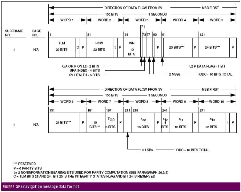
An additional example may be found in the use of navigation message data to enhance the code and carrier synchronization processes. Figure 2 (see inset, above right), taken from IS-GPS-200F, shows the details of the navigation message structure that a properly designed receiver must decode and process correctly.
The GPS navigation message consists of 25 frames, each containing 1,500 bits. Each frame is comprised of five sub-frames of 300 bits, each with 10 30-bit words. Knowledge of bit changes can be used in receiver designs to provide better tracking of the code and carrier.
GPS navigation data changes very infrequently — an important point from a receiver certification standpoint. While using data to enhance receiver performance can be helpful, it can also be detrimental if incorrect assumptions are made.
Some receiver designers have “assumed” certain data bits will remain constant although nothing in the IS that supports that assumption. So, for instance, if they implement receiver designs that do not preserve the status of reserved or extra data bits, their receivers may encounter difficulties if GPS system operators subsequently make use of those bits.
In recent years, some receivers failed when data bits were changed in pre-planned satellite signal processing uploads from the control segment. Receiver manufacturers must pay close attention to the bit structure, including reserved bits, and not assume that reserved or extra bits will always be so. These will likely be used for some future purpose and documented in an updated IS. A certification process would help ensure receivers are not designed based on assumptions unsupported by the IS.
Applications – The navigation solution provides position, change of position, and timing information to an almost innumerable number of hardware and software applications. Different applications require different elements of the navigation solution, as well as differing levels of precision from each.
Many applications require only the timing component, though position information may also be important as a cross-check on the validity of the incoming satellite signals. Many applications will also require certification of the use of the GPS navigation solution for assurance regarding the safety, continuity and effectiveness of the GPS contribution to whatever activities the application supports.
What Categories of Certification Need to Be Considered?
Different types of GPS receivers and different PNT applications need different levels and categories of certification. Technical certification of receiver operation would seem to be applicable to all GPS receiver types, although as we have seen, it has not been consistently employed to this point.
Receiver Technical Certification. Technical certification verifies that GPS receivers are designed and fabricated in conformance with relevant ISs published by the GPS Directorate. Such certification should verify proper RF signal and navigation data stream reception, including provisions for attenuation or rejection of out-of-band signal effects. It should then verify proper detection, demodulation, and interpretation of the navigation message data.
Also, very importantly, technical certification should verify proper application of all navigation message data bits as specified. Finally, it should verify proper iterative operation and application of intrinsic correction factors used in a receiver’s design to produce a navigation solution.
Parameters for technical certification include the various tracking processes that may be employed as well as specific factors relative to data application. For the code-tracking process, technical certification will assess performance relative to detection and refinement of code bit transitions as these activities have a direct effect on position accuracy and resilience of the tracking process.
For the carrier tracking process, if applicable, technical certification will assess performance relative to RF signal reception and tracking of the carrier because these activities are required for high precision and first-order velocity determination.
Certification of data demodulation and interpretation processes should assess performance relative to intended navigation message application. This includes production of the ultimate navigation solution in four dimensions and, as noted, the seamless adaptation to control segment modifications of data bit uses.
Receiver Performance Certification. Once proper technical operation of the GPS receiver is verified, additional performance certification may be necessary or desirable, depending on the intended use of the receiver. Performance certification verifies that GPS navigation solutions are processed and applied in accordance with the user-specific performance requirements.
Beyond basic technical aspects, performance certification can further evaluate the fidelity of data-detection processing and how precisely a receiver is able to determine code transitions. These are an indication of the expected precision, accuracy, or integrity of the navigation solution — important, for example, in the performance of survey or timing receivers. Aviation receiver designs are specifically certified for performance continuity and integrity.
Performance certification can also evaluate the proper application of external correction factors, such as differential information or information provided via communications channels as an aid to signal tracking (known as assisted GPS or A-GPS). Also, many receivers are subject to additional testing to evaluate their resiliency in the presence of interference. Excepting military receivers, such testing is not yet an element of performance certification, per se.
Receiver Security Certification. An additional category, at present applicable only to military GPS receivers, is certification of security components and information processing. Military receivers require high levels of signal exclusivity and protection against intentional disruption and must undergo rigorous security certification to provide assured validation of signal detection, decryption, and application. Receiver security certification also includes validation of measures to prevent unauthorized access to receiver circuitry and processing algorithms.
Some civil and commercial applications are emerging that may also require signal authentication and, presumably, a certification process to evaluate a receiver’s capability to correctly perform that function.
What’s the Final Answer?
At the moment the Final Answer to the growing need for GPS receiver standards and/or certification has yet to be determined. It will likely emerge initially from among various government users, regulatory agencies, and industry participants. However, to mitigate future confusion regarding GPS receiver performance in an increasingly demanding spectrum environment, the current ad hoc situation should not continue in government or industry.
Because this article is intended only to provide background information and a framework for further discussion, and not to define end-state solutions, some mention of scope and process options could be useful. As a first order, the GPS ISs published by the GPS Directorate provide essential technical parameters for a certification process.
To ensure some consistency of results, consensus is necessary regarding certification criteria to be drawn from the official specification documents. Application of the criteria to component- versus system-level performance parameters, and the degree of applicability of IS-based technical certification across a range of GPS receiver designs and intended applications, are examples.
With respect to certification process options, we might well consider many variations on a couple of themes: government-conducted or industry-conducted processes — examples of which I will offer in a moment. Any and all of these variations can be made to work — within agreed-upon compliance frameworks — to help ensure thoroughness of application and validation of results.
Depending on the option selected, the certification action will also involve implications for legal liability that must be addressed.
Within the government-conducted arena, the U.S. FAA issues safety certification for aviation receivers that apply to specific categories of flight operations, such as en route or terminal area. Certification is based on verifying design and manufacturing in accordance with FAA Technical Orders.
Another example: the GPS Directorate is planning a military GPS receiver certification process. This will preclude future occurrences of receiver performance anomalies caused by non-IS–compliant designs. The military certification process, once begun, may provide a basis from which to develop a model for certification processes for civil/commercial GPS receivers. However, it cannot be assumed that such an evolution will automatically occur.
As mentioned earlier, issues have arisen previously associated with use of military test facilities for testing commercial equipment, and those same issues will still have to be addressed in the future. Specifically, these include determination of revenue generation and financing mechanisms to cover the cost of commercial certification using military-funded facilities, priorities and timeliness of processing, protection of proprietary commercial (vice government-classified) information, and legal liabilities attached to the certification outcome/mark.
For industry-conducted certification, the most commonly cited model is an independent laboratory such as Underwriters Laboratory (UL), which provides a wide range of process and product-safety certification services to government, industry, and consumers. Industry and government agencies might approach UL to see if GPS receivers could be added to its diverse complement of test services. Alternatively, they might investigate the possibility for a separate independent certification provider patterned on the UL model. In any case, considerable investments in start-up capitalization and regulatory process standardization would be needed.
Further, assurance of adequate direct revenue generation (e.g., fee for service) or other sources of financing is necessary to ensure continuous operation of a GPS certification process. Additionally, industry might commit to some form of individual self-certification process as is used in indicating compliance with officially published performance standards. An example might be a vessel operator’s certification of properly performing maritime navigation equipage in accordance with published U.S. Coast Guard carriage requirements.
However, such practices would essentially perpetuate the largely ad hoc nature of current receiver performance validation and would not create the level of assurance that would be gained from a more rigorous and systematic compliance certification process.
Although no Final Answer has yet appeared, considerable interest and momentum on the part of the government is being directed toward the problem. Increased public and congressional awareness of the value of spectrum created by the LightSquared debates, and recent occurrences of GPS service performance degradation due to non-compliant receiver designs, have heightened interest in effective compliance certification processes. One might reasonably expect such interest to result in establishment of a certification process in the next few years, whether by executive direction, regulation, or statutory action.
In 2010 the National Executive Committee for Space-based PNT tasked its advisory board to assess GPS commercial receiver compliance processes. This article is adapted from an October 2011 presentation to that board.
Acknowledgments
I would like to thank Jay Purvis, Chet Arnold, Jim Burton, and Milt Clary of Overlook Systems Technologies for contributing thoughtful and value-added comments during development of this article.
Additional Resources
IS-GPS-200F, dated September 21, 2011, signed March 8, 2012
http://www.oosa.unvienna.org/pdf/icg/2010/ICG5/18october/13.pdf


