 One of 12 magnetograms recorded at Greenwich Observatory during the Great Geomagnetic Storm of 1859
 1996 soccer game in the Midwest, (Rick Dikeman image)
 Nouméa ground station after the flood
 A pencil and a coffee cup show the size of NASA’s teeny tiny PhoneSat
 Bonus Hotspot: Naro Tartaruga AUV
 Pacific lamprey spawning (photo by Jeremy Monroe, Fresh Waters Illustrated)
 “Return of the Bucentaurn to the Molo on Ascension Day”, by (Giovanni Antonio Canal) Canaletto
 The U.S. Naval Observatory Alternate Master Clock at 2nd Space Operations Squadron, Schriever AFB in Colorado. This photo was taken in January, 2006 during the addition of a leap second. The USNO master clocks control GPS timing. They are accurate to within one second every 20 million years (Satellites are so picky! Humans, on the other hand, just want to know if we’re too late for lunch) USAF photo by A1C Jason Ridder.
  Detail of Compass/ BeiDou2 system diagram
 Hotspot 6: Beluga A300 600ST

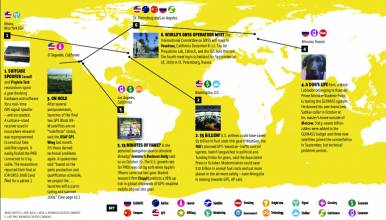
1. Portland, Oregon and Los Angeles, California USA
TWINS!
1. Portland, Oregon and Los Angeles, California USA
TWINS!
Europe’s and Russia’s twin launch trend is catching on. Col. Bernard Gruber, USAF GPS Directorate, told CGSIC listeners in Portland, Oregon last September that GPS III satellites may head out in tandem as a cost-cutting measure. The modernized SVs start going up in 2014, and dual launches could begin as early as the sixth trip.
- 51st Meeting of the Civil GPS Service Interface Committee at ION GNSS 2011
2. Kourou, French Guiana and Brussels, Belgium
THE GETAWAY
Good thing the first two Galileo IOV satellites made it safely off the
planet on October 21 . . . they just missed the space funding debate at a
high-level EU space policy conference on November 8–9. The European
Commission budget head said Galileo had been “a very unhappy experience”
and the EU’s budget structure doesn’t fit such “never-ending” projects.
- European Space Agency’s Soyuz-Galileo IOV website
- ESA News, November 11 2011: Space and its Benefit for Citizens Top Priority
- Space News, November 10 2011: Battle Over Funding Escalates
3. Moscow, Russia and Palo Alto, California USA
THE COOL FACTOR
Apple included GLONASS in the iPhone 4S. Talk about hipster cred. Financial daily Vedomosti featured the story on October 20 and said GLONASS has “suddenly reached a massive global market.” To top it off, Russia successfully launched three more GLONASS-M satellites on November 4 — a success for the recently mishap-prone Roscosmos.
- Vedomosti, October 20 2011 (Russian language) Apple Acknowledges GLONASS
- iPhone 4S specs page
4. Katmandu, Nepal
TYPHOID’S PNT
Asia-Pacific infectious disease experts combined GPS and genotyping to track typhoid fever in Katmandu, Nepal. They mapped sick houses using GPS coordinates and genotyped bacteria from each patient. How did people get sick? Mainly by infected water from bottomlands, not by person-to-person contact. This discovery suggests that typhoid can be eradicated quite simply by cleaning up public water supplies.
-
- Royal Society Open Biology Journal, October 2011, Combined high-resolution genotyping and geospatial analysis reveals modes of endemic urban typhoid fever transmission Stephen Baker et al The Hospital for Tropical Diseases, Wellcome Trust Major Overseas Programme, Oxford University Clinical Research Unit, 190 Ben Ham Tu, Quan 5, Ho Chi Minh City, Vietnam sbaker@oucru.org
5. Beijing, China
STILL WAITING . . .
At September’s ION GNSS conference, Xiangcheng Ding of the China Satellite Navigation Office confirmed that the Compass/BeiDou2 signal Interface Control Document will be published in 2011. We know it has existed in Chinese and English versions since at least 2009 . . . dare we get our hopes up once again?
Inside GNSS, September 30 2011:
GNSS Systems Reports: China’s Compass
Inside GNSS, May 27, 2010:
China’s Compass/Beidou Will Headline Shanghai NaviForum Conference
Inside GNSS, October 22 2009:
China will release Compass ICD on step by step basis
Inside GNSS, October 2009:
China’s Regional Compass System: 12 Satellites in 2012 — ICD Next Year?
Inside GNSS, December 10, 2007:
China to Reveal Compass Plans “Soon”
IMAGES AND SOURCES
1. Model of a modernized GPS III satellite on the Lockheed Martin exhibit booth at ION GNSS 2011. (Sierra Robinson photo)
2. Twin Galileo In-Orbit Validation satellites head into space on October 21, 2011 from the European Spaceport in Kourou, French Guyana aboard their Soyuz ST-B launcher (European Space Agency photo)
3. Steve Jobs, requieset in pace, shows off the iPhone 4 last year at the 2010 Worldwide Developers Conference (Wikipedia)
4. Bagmati River in Katmandu, Nepal. 2005 photo by John Kim. The river’s source is south of the Himalaya and the upper reaches are dammed. Its flow is dependent on rainfall, becoming very low from April to early June. It is polluted by agricultural and human waste and untreated garbage from the city.
5. Detail from the Beidou system application diagram on www.beidou.gov.cn 北斗”卫星导航系统应用示意图


