 One of 12 magnetograms recorded at Greenwich Observatory during the Great Geomagnetic Storm of 1859
 1996 soccer game in the Midwest, (Rick Dikeman image)
 Nouméa ground station after the flood
 A pencil and a coffee cup show the size of NASA’s teeny tiny PhoneSat
 Bonus Hotspot: Naro Tartaruga AUV
 Pacific lamprey spawning (photo by Jeremy Monroe, Fresh Waters Illustrated)
 “Return of the Bucentaurn to the Molo on Ascension Day”, by (Giovanni Antonio Canal) Canaletto
 The U.S. Naval Observatory Alternate Master Clock at 2nd Space Operations Squadron, Schriever AFB in Colorado. This photo was taken in January, 2006 during the addition of a leap second. The USNO master clocks control GPS timing. They are accurate to within one second every 20 million years (Satellites are so picky! Humans, on the other hand, just want to know if we’re too late for lunch) USAF photo by A1C Jason Ridder.
  Detail of Compass/ BeiDou2 system diagram
 Hotspot 6: Beluga A300 600ST

1. DON’T BLAME GPS
Humboldt-Tolyabe National Forest, Nevada USA
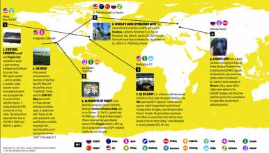
√ In the Pacific Northwest, in-car navigators often indicate “short cuts” through wilderness mountains—with tragic results. One victim survived 49 days before rescue in May. (Reports blamed GPS – not digital maps or wireless communication.) GPS.GOV straightens out misperceptions, for those who need a guardian angel, but just get a signal.
1. DON’T BLAME GPS
Humboldt-Tolyabe National Forest, Nevada USA
√ In the Pacific Northwest, in-car navigators often indicate “short cuts” through wilderness mountains—with tragic results. One victim survived 49 days before rescue in May. (Reports blamed GPS – not digital maps or wireless communication.) GPS.GOV straightens out misperceptions, for those who need a guardian angel, but just get a signal.
(May 11 2011 Oregonian) Experts say always pair GPS with paper map
2. MEGAQUAKE
Bolivia
√ GPS data from the North-South Mandeyapecua thrust fault in Bolivia shows that it is under extreme pressure and the area could face an 8.9 quake, 125 times stronger than the expected magnitude, said a new study published in May’s Nature Geoscience. The 2010 Chile and 2011 Japan earthquakes inspired many experts to reassess risk.
(May 9 2011) School of Ocean and Earth Science, University of Hawaii press release
(May 8 2011 Nature Geoscience) “Orogenic-wedge deformation and potential for great earthquakes in the central Andean backarc” Abstract
3. INTO THE SKY
Kourou, French Guiana
√ After several delays, India’s GAGAN satellite (GPS-Aided-Geo-Augmented Navigation) will take off from Europe’s Spaceport on May 21 aboard an Ariane 5 rocket. India’s space organization ISRO and the Airport Authority of India need a successful launch to advance their safety-of-life qualified aircraft navigation system. GAGAN is Sanskrit for “sky.”
(UPDATE May 22 2011, Inside GNSS ) Successful Launch on May 21 for ISRO’s GAGAN Navigation Satellite
4. DEEP SPACE PNT
Space, the final frontier
√ DARPA’s Tactical Technology Office has $8 million in 2012 to work on an advanced space system project that sounds like a Big Brother to GPS. XTIM will use X-ray pulsars to calculate position and absolute time from celestial sources, broadcast the data to earth and space . . . and help GPS. (Update the constellation ephemeris! Detect jamming and spoofing attacks!)
Defense Advanced Research Projects Agency Tactical Technology Office XTIM
5. EIGHT SATELLITES
Xichan launch center, Sichuan
√ The 8th Compass/Beidou-2 satellite, an IGSO, launched on April 10. It marked “a new stage of development,” according to the Beidou website. China intends to complete its regional system within two years, described as “independent, autonomous and compatible with the world’s GNSS interoperability” with short messaging and other China-specific services.
(April 10 2011 Inside GNSS) China Launches 8th Compass/BeiDou-2 Satellite — an IGSO
(April 14 2011 Beidou website) Chinese language interview with the chief architect of Compass/Beidou2
6. BONUS HOTSPOT! (online only)
BELUGAS! (Planes Not Whales)
√ The giant Airbus “Beluga” cargo plane is the first to be EGNOS equipped, with certification flights beginning soon, says ESA. Pau Pyrénées Airport in southern France is the first to use EGNOS safety-of-life vertical guidance signal. The plan is to to equip smaller airports with shorter runways next, with 100 complete by 2020.


