 One of 12 magnetograms recorded at Greenwich Observatory during the Great Geomagnetic Storm of 1859
 1996 soccer game in the Midwest, (Rick Dikeman image)
 Nouméa ground station after the flood
 A pencil and a coffee cup show the size of NASA’s teeny tiny PhoneSat
 Bonus Hotspot: Naro Tartaruga AUV
 Pacific lamprey spawning (photo by Jeremy Monroe, Fresh Waters Illustrated)
 “Return of the Bucentaurn to the Molo on Ascension Day”, by (Giovanni Antonio Canal) Canaletto
 The U.S. Naval Observatory Alternate Master Clock at 2nd Space Operations Squadron, Schriever AFB in Colorado. This photo was taken in January, 2006 during the addition of a leap second. The USNO master clocks control GPS timing. They are accurate to within one second every 20 million years (Satellites are so picky! Humans, on the other hand, just want to know if we’re too late for lunch) USAF photo by A1C Jason Ridder.
  Detail of Compass/ BeiDou2 system diagram
 Hotspot 6: Beluga A300 600ST

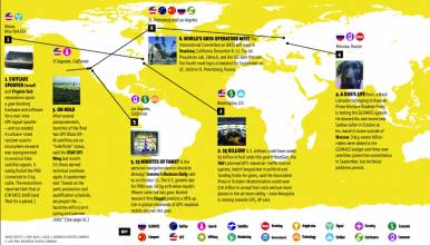
1. NORTHERN LIGHTS
Northern Hemisphere
√ The sun has been in a feisty mood lately, with solar flares mid-February to mid-March. GNSS signals haven’t been affected, because these plasma ejections have magnetic fields that are parallel to Earth, instead of perpendicular to it. That could change suddenly, according to the Space Weather Prediction Center. (Meanwhile, the Northern Hemisphere has enjoyed brilliant auroras.)
- NASA: Sun/Earth Science @ Goddard
- Aurora Forecast, University of Alaska-Fairbanks
2. BLACK BOXES UNDERWATER
Atlantic Ocean, North of Fernanda de Noronha Islands
√ Where are the two flight recorders from the mysterious 2009 crash of Rio-to-Paris Flight 447? French investigators chose Woods Hole Oceanographic Institute to begin another search of mid-Atlantic Ridge canyons beginning March 18. Three enhanced Remus 6000 AUVs, designed by WHOI and the U.S. Navy, navigate with GPS on the surface, and inertial and acoustic technology underwater. New sonar and optical capabilities raise hopes to find the black boxes.[UPDATE April 4, 2011] BEA, the French air safety authority, announced that the wreckage of Air France 447 had been found.
- REMUS 6000
- Air France 447 community website
- (FlightGlobal February 2, 2011) New Search for Missing 447
- (AP/Canadian Press March 23, 2011) 4th search for Air France jet
3. SAVING LIVES
Toulouse, France
- √ It’s official: airplanes can rely on Europe’s EGNOS signal to land. The safety of life service is ICAO– and Eurocontrol-compliant and was okayed on March 2. The European GPS augmentation system has three geostationary satellites and 40 ground control stations. It went live for ordinary navigation purposes in 2009.
4. ROBOT MINERS
Perth, Australia
√ The third largest mining company — coal and iron giant Rio Tinto — is speeding ahead with advanced remote operations. At its Pilbara site, autonomous machines use high-precision GPS for communication, wide-area networking for machine control, and proximity detection for safety. In the future, miners will “work like air traffic controllers,” the company said. (Or perhaps not have jobs at all . . .)
- (The Australian/Wall Street Journal March 17, 2011) A smarter way to dig up dirt
- (ComputerWorld/UK March 14, 2011) Rio Tinto using advanced mine automation
5. THE EARTH MOVED
Sendai, Japan
√ The 1,200 GPS permanent stations of Japan’s GEONET make it the world’s largest GPS monitoring array. Researchers used its data to report that the 9.0 magnitude Sendai Earthquake on March 11 moved the coastline nearest the quake several meters southeast. Displacement along the two fault blocks involved ranged from 20 to 157 feet (6 to 48 m) over 248 miles (400 km).
- New Zealand GEONET survey on Japanese tsunami (March 14, 2011)


