 One of 12 magnetograms recorded at Greenwich Observatory during the Great Geomagnetic Storm of 1859
 1996 soccer game in the Midwest, (Rick Dikeman image)
 Nouméa ground station after the flood
 A pencil and a coffee cup show the size of NASA’s teeny tiny PhoneSat
 Bonus Hotspot: Naro Tartaruga AUV
 Pacific lamprey spawning (photo by Jeremy Monroe, Fresh Waters Illustrated)
 “Return of the Bucentaurn to the Molo on Ascension Day”, by (Giovanni Antonio Canal) Canaletto
 The U.S. Naval Observatory Alternate Master Clock at 2nd Space Operations Squadron, Schriever AFB in Colorado. This photo was taken in January, 2006 during the addition of a leap second. The USNO master clocks control GPS timing. They are accurate to within one second every 20 million years (Satellites are so picky! Humans, on the other hand, just want to know if we’re too late for lunch) USAF photo by A1C Jason Ridder.
  Detail of Compass/ BeiDou2 system diagram
 Hotspot 6: Beluga A300 600ST

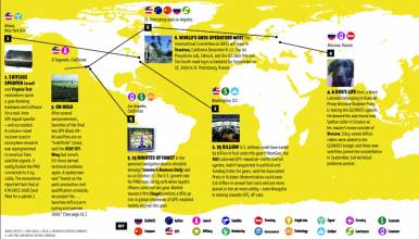
1. HURRICANE NEXT
Baton Rouge, Louisiana USA
√ Will Gulf of Mexico tropical storms become new Katrinas or nothing much? Moisture fuels hurricanes; so, NOAA and Louisiana State University researchers installed two new GPS-Meteorology packages on offshore oil platforms to gather the first Gulf ionospheric water vapor readings using dual-frequency techniques. The hope: better prediction of storm intensity and sea surge potential.
Image: Hurricane Katrina rescue from Hurricane Digital Memory Bank (hurricanearchive.org), USCG photo by PO Robert Reed.
More Information:
- The Birmingham News (Al.com) article: Click here
- NOAA GPS-MET (Ground-Based GPS Meteorology) Click here
- Seth Gutman at seth.i.gutman@noaa.gov
 2. GPS FOR EVERYONE
Iqaluit, Nunavut, Canada
√ The Inuit hunters and assorted travelers in Nunavut, the huge Canadian arctic territory, occupy an unforgiving land. So much so that the government is giving 20 GNSS handhelds to each village to lend to anyone who needs it. Lost in a whiteout? Injured on your snowmobile? Three Iqaluit officials with Blackberries are standing by.
Image: GPS-equipped Inuit hunter, Clyde River, Nunavut. Photo by Kyle O’Keefe, University of Calgary.
More Information:
- Onatsiaq Online: Click here
- Nunavut territorial government: Click here
 3. RIDING IN MY CAR, CAR
Britain, Germany, France, Spain, Italy
√ Western Europeans — 21.1 million of them — use the free navigation on their cell phones for mapping and directions services, according to April’s comScore survey. The digital marketing researchers said 68% used the satnav function while driving. Smart phones with A-GPS were even more likely to be used as “full in-car navigation devices.”
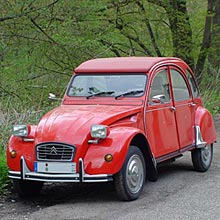
Image: The French Citroën 2CV (deux chevaux), a technical icon designed as a simple, cheap, reliable car for rough roads and off-road driving. (Wikimedia commons)
More Information:
- comScore survey: Click here
 4. PRECISION AIRDROP
Afghanistan
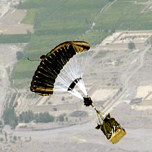
√ 30,000 pound loads can be delivered by the Joint Precision Airdrop System (JPADS), the U.S. Air Force’s GPS-guided system that uses a steerable parafoil to precision airdrop food and ammunition to troops in Afghanistan’s rough and remote areas. Controlled by piloted aircraft, it has improved airdrop accuracy by 60%. USAF is working on the UAV version now.
Image: GPS-guided Screamer 2K JPADS in Afghanistan (photo by parachute manufacturer Strong Enterprises)
More Information:
- Nextgov article: Click here
 5. GAGAN DELAYED, AGAIN
Satish Dhawan Space Center (SHAR), India
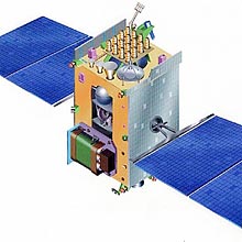
√ India’s first GPS/SBAS payload, the GAGAN transmitter on the GSAT-4 geostationary satellite, disappeared into the Bay of Bengal on April 15 when its ill-fated launch vehicle veered off course. A key part of India’s GPS augmentation plan, the failure will further delay civil aviation modernization. Indian Space Research Organization (ISRO) Chairman K. Radhakrishnan promised another launch within a year.
Image: Drawing of GSAT4 satellite (ISRO) withcommunication payload multi-beam Ka-band pipe and regenerativetransponder and navigation payload in C, L1 and L5 bands.
More Information:
- The Hindu news article (4/15/10): Click here
- Indian Space Research Agency (ISRO): Click here
 6. DO THE MATH
Perth, Western Australia
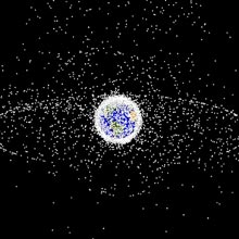
√ How is climate change affecting Australia? How can you tell when space junk is getting too close to expensive satellites? The new GNSS Research Laboratory at Curtin University of Technology just received an $8 million grant to use GNSS to develop new algorithms and methods that the federal government hopes will answer these questions.
Image: Objects in geosynchronous orbit, 95% of which are space debris. Plotted in 2005 by NASA.
More Information:
- Curtin University of Technology media release: Click here
- Peter Teunissen, leader of Spatial Positioning program, national Cooperative Research Centre for Spatial Information: Click here


