 TABLE 1: Deployment Status Note: Two types of clocks on board: PHM = Passive Hydrogen Maser, RAFS = Rubidium Atomic Frequency Standard
Europe’s new age of satellite navigation has passed a historic milestone — the very first determina-tion of a ground location using the four Galileo satellites currently in orbit together with their ground facilities.
This fundamental step confirms the Galileo system works as planned.
Europe’s new age of satellite navigation has passed a historic milestone — the very first determina-tion of a ground location using the four Galileo satellites currently in orbit together with their ground facilities.
This fundamental step confirms the Galileo system works as planned.
This first position fix of longitude, latitude, and altitude took place on the morning of March 12 at the Navigation Laboratory at the European Space Agency’s technical heart, the European Space Research and Technology Center (ESTEC), in Noordwijk, the Netherlands. The achieved accuracy of better than 10 meters met expectations, taking into account the limited infrastructure deployed so far.
This article describes a moment long awaited by the designers of the Galileo system and includes useful information for any receiver manufacturers intending to use the system for early testing.
Galileo System Status
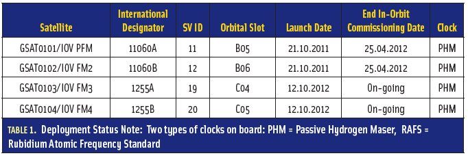
The status of the deployed Galileo satellite constellation is included in Table 1 (see inset, above right).
The Galileo in-orbit validation (IOV) satellites transmit modulated signals on all three carriers E1, E5, and E6. In particular, the composite binary offset carrier (CBOC) signal is broadcasted on E1, meeting the standard agreed with the United States for the interoperability of Galileo and GPS.
The Galileo IOV satellites signal-in-space data channels transmit navigation messages for all types of services: F/NAV corresponding to the Open Service, I/NAV corresponding to the Safety of Life, and G/NAV corresponding to the Public Regulated Service.
In the current configuration, the navigation message signal flags are set as follows:
- Signal Health Status (SHS) Flag set to “Signal component currently in test,” given that validation testing is still under way
- Data Validity Status (DVS) Flag set to “Nominal” or “Working Without Guarantee” depending on when navigation data batches are updated on-board the satellites.
Note that the SHS and DVS flags are used by receivers to determine whether or not satellite range measurements and associated navigation data can be included as valid input to the position/velocity/time (PVT) algorithm: whenever SHS is set to “Signal component currently in test” or DVS is set to “working without guarantee,” the signals from the associated satellite will be excluded from the nominal PVT algorithm.
In the coming months, the messages will be further elaborated to define the “offset” between Galileo System Time and Coordinated Universal Time (UTC), enabling Galileo to be relied on for precision timing applications, as well as the Galileo to GPS Time Offset, ensuring interoperability with GPS. In addition, the ionospheric and broadcast group delay parameters for single-frequency users will be transmitted at a later stage.
Galileo Constellation Visibility
The position fix achievement and its performance depend on the time of the test and on the location of the receivers. The location selected for the position fix is ESA/ESTEC in Noordwijk, home of the ESA’s Galileo Project Office. The activation of the navigation message generation was decided to be March 12, 2013.
With only four satellites for the time being, the complete Galileo constellation is presently visible at the same time for a maximum two to three hours daily. The focus of the demonstration campaign has been on the horizontal and vertical position fixes, with priority on the horizontal domain.
The evolution of the dilution of precision (DOP) is plotted versus time in Figure 1. As can be observed, the best time interval is between 10:00h and 11:00h UTC with a DOP value below 4. At the beginning of this time window, the global map of the horizontal DOP is depicted in Figure 2.
The skyplot of the Galileo satellites is presented in Figure 3 showing FM3 (E19) with high elevation, and PFM (E11), FM2 (E12), and FM4 (E20) with an elevation higher than 20 degrees.
Galileo Test User Receivers
A variety of test user receivers (TURs) were developed in order to assess the performance of the Galileo system from the user point of view and are key tools in its forthcoming validation. The receivers have been built in a more complex, configurable way than a typical navigation receiver in order to represent a wide range of users.
Consortia led by Thales Avionics and Septentrio, respectively, have supplied test user receivers in both navigation and PRS (Public Regulated Service) versions. The receivers are shown in accompanying photos.
In order to cover the first position-fix test, a set-up with several Galileo TURs was arranged at the ESA Radionavigation Laboratory. In parallel to the set-up deployed in the ESTEC Navigation Laboratory, a TUR was mounted in a van and a mobile test performed in the urban area of Leiden, The Netherlands, showing similar performance.
Results
The first PVT determination was achieved with all test user receivers. Figures 4 and 5 show screenshots of the PVT solutions produced by the Thales Avionics and Septentrio TURs, respectively.
Figure 6 and Figure 7 show the horizontal and vertical accuracy for the position computed by Galileo E1-E5a dual-frequency receiver. The precision of the position estimation is shown to be within expected boundaries (horizontal standard deviation around 1.5 meters and vertical standard deviation around 1.7 meters) and proves the quality of the transmitted Signal in Space (SIS).
System Performance Monitoring
Independent monitoring from the Galileo system infrastructure is provided by the Galileo Performance Center hosting the Time and Geodetic Validation Facility (TGVF) at ESA/ESTEC.
The TGVF is supported by a network of sensor stations deployed worldwide and able to receive Galileo and GPS signals and perform an accurate estimation of the satellite orbit and clock errors.
The TUR results provided previously in this article correspond to a real-time processing. The TGVF has also computed the position off-line to be used as reference, as seen in Figure 8.
In general, the accuracy is as expected, considering the effect of the local Galileo constellation geometry (or DOP) and the expected signal-in-space ranging error (SISRE) with the limited ground infrastructure. Accuracy is similar to the previous results shown for the TURs.
Future Plans
In the next month ESA will conduct IOV testing. This is an intermediate step in the Galileo system deployment aiming to confirm that the overall performance can be met before completing the full deployment of the constellation and the ground segment. The results shown on March 12 meet expectations, taking into account the limited infrastructure deployed at this stage, and demonstrate that the Galileo system works.
The validation will continue throughout this year, aiming to complete full performance characterization by the end of 2013. With the validation testing activities under way, users might still experience breaks in the content of the navigation messages being broadcast.
With only four satellites for the time being, the present Galileo constellation is visible at the same time for a maximum two to three hours daily. This frequency will increase as more satellites join them, along with extra ground stations coming online, for Galileo’s early services to start at the end of 2014.
Acknowledgments
The Galileo First Position Fix is the result of a collective effort from all European industries that have been involved in the Galileo In-Orbit Validation Phase.
The authors would like to thank the consortia in charge of the procurement of the Galileo space segment and ground segment infrastructure, namely, EADS Astrium GmbH (D) and its subcontractors, in charge of the development of the four IOV spacecraft; EADS Astrium Ltd (UK) and its subcontractors, in charge of the Ground Control Segment; Thales Alenia Space (F) and its subcontractors, in charge of the Ground Mission Segment; and British Telecom (B) in charge of the Ground Data Dissemination Network.
The Galileo position fix is part of the system integration and verification activities coordinated by an industrial consortium led by Thales Alenia Space (I). The operations at the Galileo Control Centers and the remote stations have been conducted by an industrial consortium led by Space Opal, a joint subsidiary of DLR (D) and Telespazio (I).
The test user receivers that have been used to compute the position have been developed by Septentrio (B) and Thales Avionics Space (F). The Timing and Geodetic Validation Facility for monitoring the performance of the broadcasted navigation message was developed by a consortium led by Thales Alenia Space (F) with the support from national time and geodetic laboratories in Italy, Germany, Switzerland, and France.
The definition phase and the development and in-orbit validation phase (IOV) of the Galileo program were carried out by ESA and co-funded by ESA and the European Community.
The Galileo full operational capability phase is managed and fully funded by the European Commission. The European Commission and ESA have signed a delegation agreement by which ESA acts as design and procurement agent on behalf of the European Commission.


