A 25-year (2007-2032) U.S. Department of Defense (DoD) roadmap for unmanned systems reflects the critical contribution of GPS technology in a growth area for tactical military systems that are simultaneously seeking a compatible place in civil applications and the national air space.
A 25-year (2007-2032) U.S. Department of Defense (DoD) roadmap for unmanned systems reflects the critical contribution of GPS technology in a growth area for tactical military systems that are simultaneously seeking a compatible place in civil applications and the national air space.
The roadmap prioritizes the DoD’s funding and development of unmanned systems technology, which will reach $2.8-billion in Fiscal Year 2008 (FY08) rising to more than $4 billion by FY10. Acquisitions of operational UASs will reach more than $11 billion in the FY 2007-13 time frame out of a projected $24 billion-plus total budget for unmanned systems.
Umanned aircraft systems (UASs) currently dominate the attention currently being given to unmanned systems with a majority of DoD spending already crossing from research, development, test and evaluation (RDT&E) to procurement of operational unmanned aerial vehicles (UAVs).
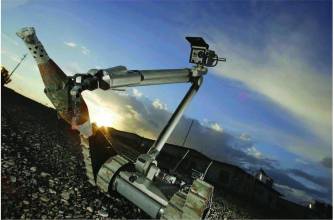
Nonetheless, land vehicles and maritime vessels are slated to receive large increases in funding for comparable systems for such applications as mine countermeasures (MCM) and solutions to the pervasive danger created by improvised explosive devices (IEDs).
Combat operations in Iraq and Afghanistan are driving the interest and acquisition of UAVs in particular — much as the 1990-91 Gulf War popularized the use of GPS receivers among the military services.
GPS-aided unmanned systems range from the 13-ounce Tactical Mini-Unmanned Aerial Vehicle (TACMAV) with its 21-inch wingspan and reconnaissance and surveillance sensors through the well-known Global Hawk and Predator airborne systems to the Army’s 9.3-ton armed robotic vehicle and the Navy’s portable Swordfish unmanned underwater vessel. The Swordfish can perform low-visible exploration and reconnaissance in support of amphibious landing, MCM operations, and hydrographic mapping in very shallow water.
The roadmap was discussed in a December 18 briefing by Dyke Weatherington, deputy director of the Unmanned Aerial Systems Task Force that had recently delivered a 188-page report to the Office of the Secretary of Defense. The DoD’s long-term plan is to publish a “truly integrated Unmanned Systems Roadmap” in January 2009 that builds on the task force’s effort and increases the focus on manned and unmanned systems interoperability.
The report features a cameo appearance by the Defense Advanced Research Projects Agency (DARPA) Grand Challenge for autonomous ground vehicles and its 2005 winner, Stanford University’s Stanley.
The January/February 2008 issue of Inside GNSS will feature a Working Papers column by Maria Bento that discusses the various types of UAVs, their GPS/inertial navigation and guidance systems, and the challenges of integrating additional sensors to overcome technical limitations for such matters as collision avoidance and control of multiple unmanned aircraft systems.


