As anyone who’s been there knows, Boston is one of the best places in America for home-grown Italian cooking. And the city is also home to one of the world’s greatest St. Patrick’s Day parades. Another slightly lesser known but no less impressive product of the Boston melting pot is top-flight GNSS man Christopher Hegarty.
Christopher Hegarty’s father was born and grew up in Boston. He is 100% Irish, and both of his parents were born in Ireland, Hegarty told us. Christopher’s mother was also born and grew up in Boston. She is 100% Italian, and both of her parents were born in Italy.
“My father came from humble beginnings,” Hegarty said. “His father was a day-laborer and his mother worked as a seamstress. My mother’s father worked as a chef in Boston.”
From Whence He Came
“My parents met as teenagers,” Hegarty said, “when my father spotted my mother as he was checking groceries at a supermarket.” Coming from different “communities” and all, would the sharp-eyed youngsters, when the folks realized where all this was heading, have faced any obstacles (see “Montagues and Capulets”)?
“My parents were married in the late ’50s,” Hegarty explained. “They’ve told many stories about their younger days, but I don’t recall anything about the families clashing. I think in Boston the Irish and Italians were pretty familiar communities by then.” And we can confirm that they remain so today. What a festive time it must have been when the two sides came together for the wedding!
It worked out in the end for Christopher’s parents. Cutting to the chase, his parents graduated with bachelor’s degrees from Boston-area colleges. His father went on to become a surgeon, no less, having partially paid for his education by doing construction as an iron worker. His mother contributed as well, working in the medical field.
Due to his father’s residency at the University of Vermont hospital, Christopher himself was not born in Beantown but in Burlington, Vermont. But the family returned to the ground from which it had sprung in time for him to grow up in the Boston suburb of Chelmsford.
“Childhood was a good experience for me,” Hegarty recalled. “There were lots of kids in our neighborhood, lots of pickup football, baseball, basketball, hockey games, and general roaming around. And for some reason I remember there were lots of dogs too, back before folks really paid attention to leash laws. There was a general freedom we had back in the day, riding bikes around town, buying baseball cards at the corner store, playing with my three sisters and friends in the yard.
“My parents always encouraged their kids to do activities growing up. I played sports in elementary and middle school – Little League baseball and soccer. And we downhill skied as a family in the winter. They also made us take music lessons. I chose guitar.”
“When I was in high school, I mostly worked after school – paper route, custodian at Apollo Computers, then a number of years working at a carpet store, mostly in the shop, unloading carpet and pads off trucks, loading them on installers’ vans, running miscellaneous errands.”
How He Made His Way in the World
 As their children grew up, Christopher’s parents always remained supportive of their academic and professional moves. “Worcester Polytechnic Institute was the only school I applied to, and I did early admission,” he said. He earned his first degree, a B.S. in Electrical Engineering, in 1990.
Next step was graduate school. “I stayed on at Worcester Polytechnic to work on a Master’s degree, and that was when I got my first real taste of GNSS.” And quite a taste it was: “I was a Research Assistant for Professor Per Enge. I was one of his last M.S. thesis students before he left for Stanford University to work with Brad Parkinson et alia on the AIAA GPS Blue Books, which were published in 1996.”
Hegarty worked on two projects for Enge – one looking at methods to compress RTCM SC-104 data for the USCG and one to simulate the GPS Integrity Channel (GIC), which was the precursor name for what later become known as the Wide Area Augmentation System (WAAS) and similar international Satellite-based Augmentation Systems (SBAS).
The GIC development project was funded by Inmarsat, and the Enge group worked with Alison Brown and her staff at Navsys. The RTCM SC-104 compression work was motivated by a desire to improve differential positioning performance over slow data links. It was never implemented. “With the GIC work, we wanted to increase GPS performance to the levels required to safely navigate aircraft in instrument meteorological conditions,” said Hegarty. “Some of the lessons learned during my research influenced the later algorithms used for WAAS.”
For his superb work with Enge, Hegarty received his M.S. in Electrical Engineering in 1992. “And Per had a lot to do with me getting my first job at MITRE,” Hegarty said. “He had been working with Ron Braff on the ION’s (Institute of Navigation) quarterly journal, and Ron arranged an interview that led to my being hired by MITRE in June 1992.”
The MITRE Corporation is a U.S. not-for-profit organization based in Bedford, Massachusetts, and McLean, Virginia. It manages federally funded research and development centers (FFRDCs) that support several U.S. government agencies.
Hegarty’s first position, which he held from 1992-1995, was Senior Systems Engineer: Navigation and Surveillance Department, at MITRE’s Center for Advanced System Development, based in McLean. Then, from 1995-1997, still in the same department, he worked as Lead Engineer.
During these early years at MITRE, Hegarty continued to expand his academic horizons as a doctoral student at George Washington University, in nearby Washington, D.C., specializing in Spread Spectrum Communications.
But all work and no play make Chris a dull boy, so…
How His Call was Answered
With two serious items already on his plate, that is a big-time job and a doctoral degree in progress, Hegarty pulled off the grand trifecta, the “heck-yeah hat trick”, if you will, by going out and winning the heart of his future wife. Talk about multi-tasking. Or maybe it was the other way around. No matter.
“I met Patti when we were both working at MITRE,” Hegarty said. “She was working as an engineer.”
This we can all agree on: when two high-flying engineers come together there can be very little room for misinterpretation. The meaning was clear and the way to proceed was obvious. Hegarty quickly completed his D. Sc. degree in Electrical Engineering in 1997, becoming the second Dr. Hegarty in his family, and then he completed the heck-yeah hat trick by marrying Patti in 1998.
“Patti had been married previously and had a daughter, my step-daughter Michelle,” Hegarty said. “And we subsequently had two children together, David, then Megan.”
But we are getting slightly ahead of ourselves.
In 1997, armed with his new D.Sc., Hegarty was made Project Team Manager: Navigation and Surveillance Department, at MITRE’s Center for Advanced Aviation System Development (CAASD) in McLean.
This from the MITRE website: “With its unique laboratories, modeling, simulation, and analytic capabilities, the CAASD has supported the Federal Aviation Administration’s (FAA) mission for over 50 years. It is currently working closely with the Administration to develop NextGen – the next-generation air transportation system.” If you are reading this, you probably already know how important that is.
In 2002, Hegarty finally returned, with his family, to the state where he had grown up, having claimed a new position as Senior Principal Engineer: Communications, Navigation and Surveillance Division, at MITRE’s CAASD facility in Bedford, Massachusetts, not far from his old Chelmsford stomping grounds.
What He Did
“I stumbled into the field of GPS,” Hegarty admitted, “only because I had heard that Per Enge was a very good professor to do a M.S. thesis with. I can say I never expected to still be working on GNSS 25-plus years later! What has kept me involved is that one can never get bored working in this field. GNSS involves so many sub-disciplines – electrical engineering, mathematics, statistics, geodesy, geophysics, space weather, relativity, etc., etc. I am still learning something new every day.”
In those 25+ years, Hegarty has been involved in several key projects. Here are just a few:
• GIC/WAAS – “I’ve supported the FAA’s WAAS program on and off for decades,” Hegarty said. “This system is of course now operational and since 2003 has been used for navigation of aircraft in IMC. I contributed to the message formats and receiver algorithms.”
• GPS Civil Signals – Hegarty helped select the GPS L5 frequency and then co-led, with Dr. A.J. Van Dierendonck, the development of the initial GPS L5 signal specification (RTCA DO-261) that was later converted by the U.S. Air Force (USAF) into what is now the Interface Specification IS-GPS-705. “The initial signal specification defined most of the L5 signal characteristics, including the modulation characteristics and the flexible message format later adopted for use also by L2C,” he said. “I also participated in the GPS L1C design team and contributed to the development of the L1C modulation design and message format.”
• DOT GPS Adjacent Band Compatibility (ABC) study – Hegarty led a MITRE team that provided the GNSS signal generation equipment for the Department of Transportation (DOT) ABC testing at White Sands Missile Range. “We operated the equipment and also nearly a dozen GNSS receivers for that test. We also were significant contributors to the analysis and co-authored the final report. We worked very closely with DOT leadership and other contributors, such as Zeta Associates, USAF, NASA, and various GNSS receiver vendors.”
What He’s Currently Doing
And the beat goes on. Hegarty’s most recent promotion came in 2018 when he was made a Technical Fellow, and he continues to break new ground:
• Dual-frequency Multi-constellation (DFMC) GNSS avionics – “I co-chair, with Dr. George Ligler, RTCA Special Committee 159 (GNSS) which develops GNSS avionics standards and other GNSS products.” SC-159 participants come from around the world and represent most major avionics vendors, airframers, and civil aviation authorities. Until May 29, SC-159 served as a Federal Advisory Committee for DOT/FAA. “Since then,” Hegarty said, “we have continued to develop standards as an independent standards organization functioning in much the same way despite the change [For more on this topic go to: https://insidegnss.com/rtca-is-no-longer-an-faa-advisory-committee/]. SC-159’s current focus is on the next-generation GNSS avionics, which will be dual-frequency (L1/L5) and multi-constellation – GPS+Galileo+ possibly BeiDou/GLONASS – whereas most current-generation avionics only process GPS+SBAS C/A-code signals.” A DFMC GNSS antenna standard was approved in June. The DFMC GNSS (SBAS) receiver standard is scheduled to be completed in two iterations – an initial version for verification/validation in 2020 and a final version in 2022. Each of two iterations (initial/final) of DFMC GNSS (GBAS) standards are scheduled to be delivered a year after the corresponding GNSS (SBAS) standard.
• GNSS Radiofrequency Compatibility bilats/multilats – Since the late 1990s, Hegarty has been a member of various U.S. bilateral/multilateral teams that have met with other GNSS service providers to ensure that other GNSS constellations are radiofrequency compatible with GPS. “This has included numerous meetings with Europe, China, Russia, Japan, India, among others,” he said, “and has resulted in a number of formal agreements. One challenge we have faced is protecting GNSS from self-interference problems with the rapidly growing number of GNSS satellites, including SBAS geostationary satellites.”
• Artech House GNSS Series Co-editor – Since 2006, Hegarty and Elliott Kaplan have been co-editors of Artech’s GNSS Series. “Our text, ‘Understanding GPS/GNSS: Principles and Applications’ is the flagship of the series,” Hegarty said. “The second edition was published in 2006 and the third edition in 2017. Over 7,500 copies of these two editions have sold worldwide thus far. The second edition has been translated into Chinese, and the third is now in translation. There are more than a dozen other titles in the series thus far.”
Meanwhile, Hegarty has remained busy as a teacher, for a while as a part-time Professor at George Washington University, since 2000 for Navtech Seminars, and also a number of subjects internally for MITRE.
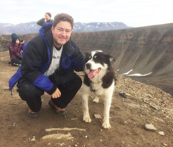
He has even had occasion to enjoy a few perks: “Every summer but one since 2007, I’ve taught at what is now referred to as the ESA/JRC GNSS Summer School in Europe,” he explained. “These have been like vacations for me – a few hours of lecturing, but most of the time spent conversing with the other lecturers and students, or in some scenic location hiking. My son joined me one year in Davos, Switzerland, and we hiked and mountain-biked. Last year, I had the opportunity to spend time in Svalbard, which is about 80N in latitude. This July the summer school was in Austria and my daughter joined me for her first trip to Europe.”
How He Came Full Circle
 Christopher Hegarty, it can be argued, has it all. But getting it all has implied certain trade-offs. “One challenge that we’ve faced is that I’ve had a lot of work-related travel over the years,” Hegarty said. “We’ve been fortunate that Patti was willing to stop working and stay home to take care of the kids, house, and finances. She has also found time to volunteer at local schools and tutor some high school kids in mathematics,” Hegarty said.
The arrangement seems to have worked. “Michelle and David are now off at college – Michelle for graduate studies and David as a college freshman. And Megan is 13 and just starting eighth grade.”
“We have and will continue to encourage all of our children to pursue their interests in whatever fields that may choose.” A wise policy that Hegarty may have picked up from his own parents.
For all his accomplishments, family clearly remains a key source of strength and comfort in Hegarty’s life. “Spending time with my wife and kids is extremely important to me, as is getting together with extended family,” Hegarty said. “I have three sisters. My sisters and I had a lot of fun growing up. There is no doubt that interacting with them shaped my life. We spent a lot of time together, at least until we were old enough to drive. We still get together for holidays and other special events, along with our parents, who are doing well.”
Hegarty’s oldest sister went on to become a lawyer until she decided to retire from that business and open an antiques shop with her husband, also a former lawyer. Hegarty’s next oldest sister, as it happens, is the accomplished New York City artist Valerie Hegarty, and his younger sister holds degrees in biology and is doing some great environmental work, he said.
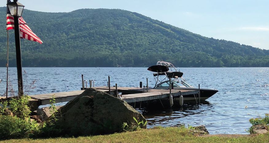
While his work has placed great demands on Hegarty in terms of time and energy, he pointed out, “Engineering has also been a rewarding career path that has enabled me and my family to pursue and enjoy a lot of other interests. For example, my parents owned a cabin on a lake in Maine for decades and Patti and I were able to buy it from them a few years ago. We enjoy a lot of water activities, hiking, biking, and family time there.”
And just to round out the picture, we note that Hegarty is an avid woodworker, who has made, among other things, a desk for his step-daughter, a custom loft bed for his son, and other items around the house, like a TV stand and a wet bar for the basement. Here, he said, his engineering background has come in handy: “I have used a fair amount of trigonometry for dimensioning the pieces for various projects! And I also like to read and I still play guitar, and work on the house.” Ever the multi-tasker.
Whatever else we know about Christopher Hegarty – all work, all play, all-American – he is no dull boy.
Compass Points
Professional Path
Since receiving his Master’s degree from the Worcester Polytechnic Institute, Dr. Christopher Hegarty has spent his entire professional career working for the same organization, the MITRE Corporation, mostly within the Center for Advanced Aviation System Development (CAASD), based in Virginia, and in his home state of Massachusetts. Since 1992 he has served in various positions from a member of the engineering staff to his current role as a Technical Fellow.
Engineering Specialties
Hegarty’s B.S., M.S., and D.Sc. degrees are all in electrical engineering, with a focus on statistical communications theory and spread spectrum signal/receiver design.
Other Technologies
Hegarty works primarily on applications of satellite navigation for civil aviation, but has also worked on projects involving various other navigation, communication, and surveillance systems. As chair of the RTCA Program Management Committee, which has oversight of all of the RTCA’s Special Committees (SCs), he comes into contact with many other aviation technologies, including: integration of unmanned aircraft into civil airspace, GNSS, automatic dependent surveillance – broadcast (ADS-B), traffic alert and collision avoidance systems (TCAS/ACAS), aeronautical information and meteorological data link systems (AIS/MET), secondary surveillance radars (ATCRBS/Mode S), enhanced flight/synthetic vision systems (EFVS/SVS), data communication services (VHF, satellite, IP, and AeroMACS), aeronautical system and airport security, aeronautical databases, flight management systems (FMS), emergency locator transmitters (ELTs), airborne weather detection systems, and Wireless Avionics Intra-Communication Systems (WAIC).
Engineering Mentor(s)
Per Enge stands as one of the grand figures in the history of GNSS, and Hegarty had the good fortune to be associated with him as a young student. “Per was my first GPS mentor and truly an absolute pleasure to work for. I had the good fortune to work with him on various projects after he settled at Stanford.”
Hegarty also cites Dr. A.J. Van Dierendonck as an important figure in his academic and professional life. “A.J. has taught me a great deal of GNSS receiver design since I first met him in the early 1990s,” he said. “I’ve been fortunate to be able to work with him on many projects over the last couple of decades.”
GNSS Event that Most Signified to You that GNSS had “Arrived”
Hegarty knew that GNSS had become a true cultural phenomenon when he heard one of his kids singing the “Give a Give a Garmin” song one Christmas season after seeing the ad on television.
What Popular Notions About GNSS Most Annoy You?
One of Hegarty’s pet peeves, he said, is with the usage of the term “GNSS”: “I’m fond of the original definition of GNSS as the ‘global collection of all satellite navigation systems and their augmentations’. Recently, a second definition of GNSS as ‘any single global satellite navigation system’ has come into favor, resulting in widespread confusion.”
As a Consumer, What GNSS Product, Application, or Engineering Innovation Would You Most Like to See?
Hegarty would like to see the miniaturization of atomic inertial sensors that would allow mass-market devices using GNSS + inertial + other sensors to work satisfactorily in many areas where current devices do not today.
Favorite Equation
The Weiner-Khintchine equation:
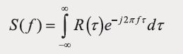
“First of all,” Hegarty said, “it is just a Fourier transform, and one of my favorite undergraduate classes was on signals and systems where students were first taught that most time-domain waveforms can be decomposed as a summation of sinusoids. Second, it involves concepts in random processes, which is a topic I also enjoy and use a great deal in my work.”
Patents Held and/or Pending and When Achieved/filed for What Specific Applications/products/markets:
Time-Multiplexed Binary Offset Carrier Signaling and Processing (US 2008/0260001A1 and 2010/0284440 A1). These two U.S. Patent Applications were Expressly Abandoned by MITRE after publication to allow universal free access to the inventions that are related to the generation and reception of the time-multiplexed binary offset carrier (TMBOC) modulation that was developed for the 4th civilian GPS signal, L1C.
System and Method for Detecting GPS Anomalies (US 2014/998,837). This published patent application is for a method to protect GPS receivers from certain anomalies.


