201607 July/August 2016 Archives - Inside GNSS - Global Navigation Satellite Systems Engineering, Policy, and Design

201607 July/August 2016

July 17, 2016

Air Force Backs GPS OCX as Temporary Shutdown Looms

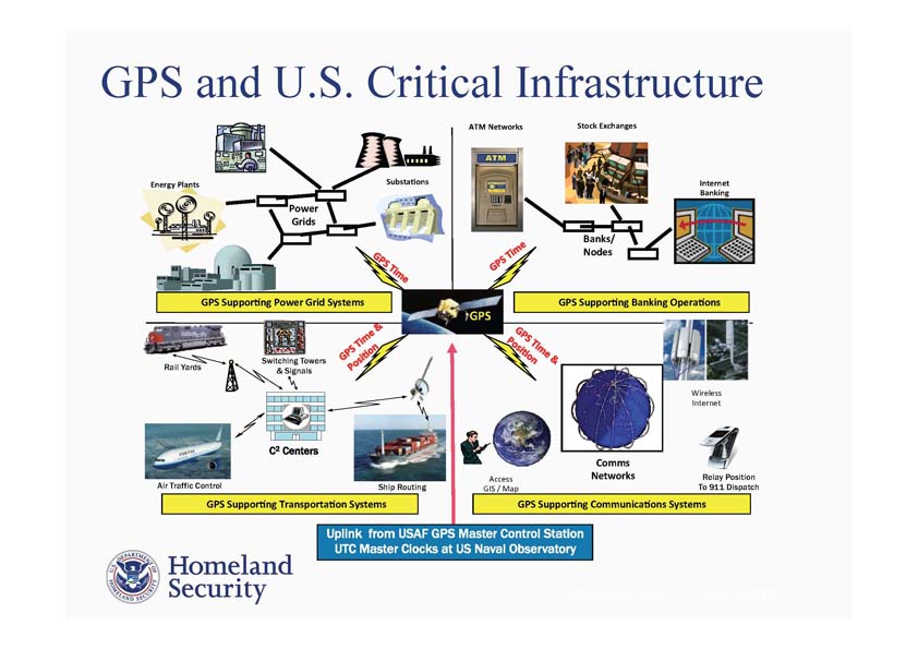
The Air Force is defending the new GPS ground system, taking a stand against naysayers in Congress and declaring through its actions an intent to stick with the Next Generation Operational Control System program (OCX) — at least for now.

The most public of these actions occurred June 30 when Secretary of the Air Force Deborah Lee James announced OCX would surpass by at least 25 percent the program’s estimated cost. She declared a critical Nunn-McCurdy breach, putting the program on a path to automatic cancellation.

Read More >

By Dee Ann Divis

Jade Morton: The Long and Scintillating Road

Jade Morton, in the front row at the right, with her sisters and grandmother

>>Jade Morton’s Compass Points

Yu — or Jade, in English — Morton is an electrical engineer, a professor at Colorado State University (bound for the University of Colorado Boulder in 2017), and a shining star in the world of GNSS. She left work for eight years to be a full-time mother, then returned to a university professorship and high-level research, where she has been recognized for her work on ionospheric effects on global navigation satellite systems.

Read More >

By Inside GNSS
[uam_ad id="183541"]
July 8, 2016

Department of Transportation Calls for More Testing of GPS/GNSS Receivers for Adjacent Band Compatibility

DoT Assistant Secretary for Research and Technology Gregory Winfree

A Federal Register notice published on July 7, 2016 announced Department of Transportation (DoT) plans to conduct additional testing of GPS/GNSS receivers this month as part of  their Adjacent Band Compatibility (ABC) Study. The notice was issued by DoT Assistant Secretary for Research and Technology Gregory Winfree.

Read More >

By Inside GNSS
July 6, 2016

Interference Mitigation in the E5a Galileo Band Using an Open-Source Simulator

Four global navigation satellite systems are scheduled to be fully operational orbiting Earth in the coming years: the NAVSTAR Global Positioning System (GPS) from the United States, the GLObal NAvigation Satellite System (GLONASS) from Russia, the Compass/BeiDou-2 System (BDS) from China, and Galileo from Europe. A considerably high number of signals, coming from the satellites of those constellations, will share the radio electric spectrum.

Read More >

By Inside GNSS

The Emerging Legal Debate Around Japan’s QZSS

Japan’s regional and augmentation positioning system, the Quasi-Zenith Satellite System (QZSS), is a project yet to be developed. While it will become a constellation of seven satellites covering the western Pacific area, only “Michibiki,” the first satellite launched in 2010 for technological validation , is now in orbit.

Read More >

By Ingo Baumann
[uam_ad id="183541"]
July 5, 2016

First Results

In February 2011, Russia launched the first satellite of the GLONASS-K1 series, i.e., SVN (space vehicle number) 801 (R26), which in addition to the legacy frequency division multiple access (FDMA) signals, for the first time was enabled to transmit code division multiple access (CDMA) signals on the GLONASS L3 frequency (1202.025 MHz). Later in 2014, the GLONASS program added SVNs 802 (R17) of series K1 and 755 (R21) of series M, and in 2016, SVN 751 of series M, with the capability of transmitting CDMA L3 signals to the constellation.

Read More >

By Inside GNSS

The International GNSS Monitoring and Assessment Service

Contemporary times have seen an increase in the number of navigation satellites across various geographical regions. In order to ensure that all these satellite systems work together to optimize the positioning, navigation, and timing (PNT) of users on or near the Earth’s surface there is need for inter-cooperation and inter-operability of the systems.

Read More >

By Inside GNSS

Federal Agencies Plan Shutdown of 37 Differential GPS Stations

Graphic Depicting NDGPS Coverage After Site Reductions

The U.S. Coast Guard, the U.S. Army Corps of Engineers (USACE), and the Department of Transportation (DoT) released a Federal Register notice today (July 5, 2016) announcing a reduction of the Nationwide Differential Global Positioning System (NDGPS).

The planned reduction calls for the shutdown and decommissioning of 37 DGPS sites, leaving 46 operational sites available to users in coastal areas. Termination of the NDGPS broadcasts is scheduled to occur on August 5, 2016.

Read More >

By Inside GNSS
July 1, 2016

Army Plans Awards, Solicitations for Assured PNT with(out) GPS

The U.S. Army will soon release new contracts and a post-Milestone B solicitation as part of its shift to a system of systems approach for making sure warfighters have the position, navigation, and timing (PNT) information they need regardless of issues with getting the GPS signal.

The Assured PNT (APNT) approach incorporates multiple sensors and an open architecture into an integrated whole that is resilient and easy to update, explained Kevin Coggins, the direct reporting program manager for PNT.

Read More >

By Dee Ann Divis

Homeland Security, PNT ExCom Move on Backing Up GPS

Harold “Stormy” Martin, director NCO for Space-Based PNT

The Department of Homeland Security (DHS) is moving forward to establish a backup for the position, navigation, and timing (PNT) information provided by GPS. This month the agency assumed the lead in a yearlong effort to specifically define the requirements for an alternative source of timing information to and released a solicitation for research to help protect critical infrastructure from timing disruption or spoofing.

Read More >

By Inside GNSS
IGM_e-news_subscribe