Global Navigation Satellite Systems Engineering, Policy, and Design
Global Navigation Satellite Systems Engineering, Policy, and Design

Honestly, one gets the feeling that the European navigation community has finally had enough of talking and is ready to take Galileo out of the hands of politicians and put it into the hands of users, including businesses that can translate European GNSS into real products and services to be bought and sold.
The feeling has certainly been growing within the European navigation community, as evidenced by the conversations at the recent European Navigation Conference (ENC) in Vienna.
By Peter Gutierrez
Q: How do you deal with timing differences between GNSSs?
A: All GNSSs inherently depend on precise timekeeping to measure the satellite/receiver time of flight of signal propagation with sufficient accuracy to compute ranges/distances for multilateration calculations. Each GNSS ground segment therefore dedicates considerable effort to maintaining a highly stable atomic time scale as well as the corresponding offset to global standards such as UTC (Coordinated Universal Time).
By Inside GNSS
 Jan Brecht-Clark, director, National Coordination Office for Space-Based Positioning, Navigation, and Timing
With just more than four months to go in the 2013 fiscal year, sequestration and furloughs are taking a bite out of key research and the work of the National Coordination Office (NCO) for Space-Based Positioning, Navigation, and Timing (PNT) — the government nexus for GPS-related policy matters.
The NCO is an interagency organization, explained its director, Jan Brecht-Clark in an emailed response; so, “each individual staff member is subject to furloughs implemented by their home agency as a result of sequestration.”
By Inside GNSS
The fourth China Satellite Navigation Conference (CSNC 2013) wound up its three-day run on Friday (May 17, 2013) in Wuhan — by most measures a clear success for an event that has become the nation’s leading GNSS forum.
Well more than 2,000 attendees had their choice of 627 technical papers spread across a broad array of topics in 12 session tracks under the conference theme: BeiDou Application — Opportunities and Challenges.”
By Inside GNSS
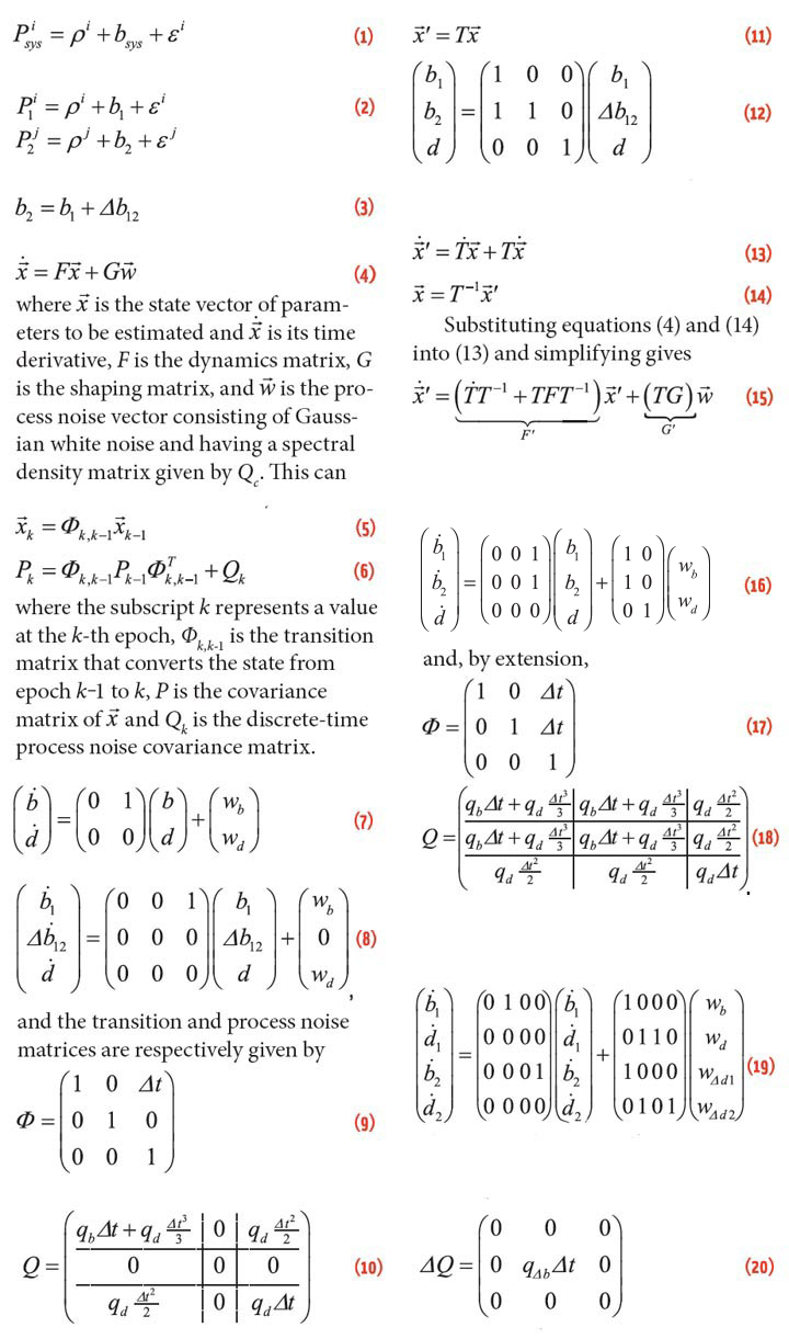
The four Galileo in-orbit validation (IOV) satellites now on orbit have begun broadcasting the “offset” between the GPS and Galileo system time, accurate to a few billionths of a second, according to the European Space Agency.
With satellite navigation based around the highly accurate measurement of signal travel times, both Galileo and GPS have their own internal reference time systems used to synchronize all system clocks, including those in the ground segment, on satellites, and in receivers. Galileo System Time is about 50 nanoseconds or less apart from GPS time.
By Inside GNSS
Return to main article: "Boeing’s Little Bird UAV"
By Inside GNSS
Return to main article: "Boeing’s Little Bird UAV"
By Inside GNSS
Return to main article: "Boeing’s Little Bird UAV"
By Inside GNSS
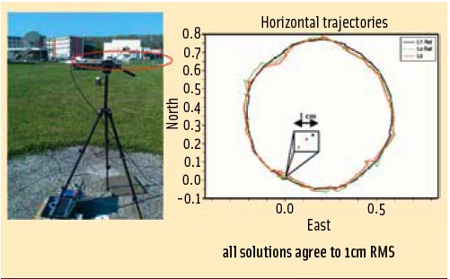 FIGURE 1: ISTA (left) and GATE (right) measuring vans at the parking place at the GATE site in Berchtesgaden
Working Papers explore the technical and scientific themes that underpin GNSS programs and applications. This regular column is coordinated by Prof. Dr.-Ing. Günter Hein, head of Europe’s Galileo Operations and Evolution.
For the complete story, including figures, graphs, and images, please download the PDF of the article, above.
By Inside GNSS
Existing methods for improving the GNSS performance commonly attempt to enhance the signal processing and navigation estimation parts of a single receiver. Such approaches, however, leave unexplored the potential benefits inherent to the integration of data from multiple receivers.
By Inside GNSS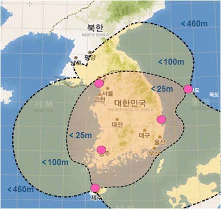 Projected accuracy and coverage of Korea’s eLoran network. Ministry of Oceans and Fisheries of Korea
GPS jamming attacks from North Korea that have increased in frequency and duration since they began August 2010 have prompted the South Korean government to implement an enhanced Loran (eLoran) systems that will cover the entire country by 2016.
The South Korean government completed design, development, and construction documents for the eLoran system in February and will procure the system infrastructure through international competitive bidding.
By Inside GNSS
 Allure Shadow (top), structural clearances (bottom)
The Boeing Company initiated the Unmanned Little Bird (ULB) program in the fall of 2003 to create a developmental platform for an optionally manned, vertical takeoff and landing (VTOL) unmanned aerial vehicle (UAV). Initial flight test activity employed a modified MD530FF helicopter, with the first flight taking place on September 8, 2004. Six weeks later the program achieved a fully autonomous multiple waypoint demonstration flight from takeoff through landing.
By Inside GNSS