Roads and Highways Archives - Page 4 of 17 - Inside GNSS - Global Navigation Satellite Systems Engineering, Policy, and Design

Roads and Highways

June 23, 2020

Update to GNSS Firewall Software Strengthens Critical Infrastructure Protection

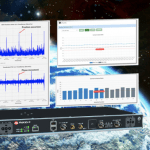
Microchip Technology Inc. has released a software update for its BlueSky GNSS Firewall product, providing a higher level of resiliency against GPS vulnerabilities for systems dependent on GPS signal reception. Such critical infrastructure systems include power utilities, financial services, mobile networks and transportation, all relying on GPS-delivered timing to ensure ongoing operations.

Read More >

By Inside GNSS
[uam_ad id="183541"]

Galileo on PATROL for Driver and Road Safety

The Position Authenticated Tachograph foR OSNMA Launch (PATROL) project is developing the first external GNSS facility for smart tachographs, using Galileo’s new Open Service Authentication (OS-NMA). The tachograph, a device fitted to a vehicle that automatically records its speed and distance, together with the driver’s activity selected from a choice of modes, uses Galileo authentication to verify that the navigation data received from satellites is genuine.

Read More >

By Inside GNSS
May 18, 2020

Photonic Technology Brings a Cutting Edge to Inertial

Order-of-magnitude advances in inertial technology seem to take place roughly every 20 years, and the industry is poised at such a point now. New developments in photonic technology make high-performance inertial measurement accessible at lower size, weight and power. Many applications from driverless cars to UAVs can now take advantage of positioning that can independently bridge GPS outages from 2 minutes up to 10 minutes.

Read More >

By Inside GNSS
[uam_ad id="183541"]
May 11, 2020

Galileo Green Lane Speeds Border Crossings of Essential Goods

A new mobile app, Galileo Green Lane, facilitates the free movement of freight, reduces waiting times at European Union borders, and prioritizes essential goods during pandemic response. The app uses Galileo positioning services  to address the needs of border control authorities and truck drivers, with two intuitive user interfaces. The app was developed by the European GNSS Agency (GSA) in collaboration with the European Commission.

Read More >

By Inside GNSS
March 13, 2020

Signal Vulnerability.

Previously, controlled reception pattern antennas (CRPAs) were only in the military domain, and highly classified. The need to counter increasing  GNSS signal jamming and spoofing in the civil realm has brought CRPAs into limited use there as well.  How to test for their efficacy in product design and development?

A free webinar on Wednesday, March 25 from 1:00 PM – 2:30 PM Eastern Daylight Savings Time addresses the topic “GNSS Vulnerability Testing and the Controlled Reception Pattern Antenna (CRPA).” This technically rich, educational event is sponsored by Spirent Communications and Inside GNSS.

Read More >

By Inside GNSS
IGM_e-news_subscribe