
 CDGPS coverage map. NRCan image
The Canada-wide DGPS Service (CDGPS), a free GNSS augmentation system initiated by the Canadian Council on Geomatics (CCOG) in 2003, will be decommissioned by March 31, 2011, according to Gary Sawayama, the system’s general manager.
The CDGPS L-band broadcast has been carried by SkyTerra Communications Inc.’s MSAT communications satellites, which are expected to be replaced this year by the next-generation SkyTerra satellites. Significant new investment in infrastructural changes would be required to migrate to a new communication satellite.
Given that several alternatives to CDGPS are now available, including commercial correction services, the requirement for a government-provided free service has been reduced, prompting the decision to cease operation of CDGPS, Sawayama says.
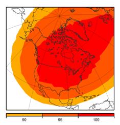
Introduced as a public service for the Canadian positioning market, CDGPS has a North American footprint that extends from Mexico to 15 degrees north of the Arctic Circle. The service reportedly provided meter-level real-time GPS accuracies for single-frequency GPS receivers and sub-meter accuracy of dual-frequency receivers.
The GPS correction data — based on algorithms developed by Natural Resources Canada (NRCan) and positioning data from Canadian and International GNSS Service (IGS) reference stations — is optimized for North America.
According to SkyTerra’s 10-K filing on February 25, 2010, their projected launch window is from August through October 2010. Following an in-orbit test and verification period, the MSAT traffic will be transitioned to the new SkyTerra satellites. Conceivably, that CDGPS’ L-band services on MSAT may remain operational well into next year. However, CDGPS customers will receive 60 days notice if MSAT services transition to the new satellite network before March 31, 2011.
CDGPS has been broadcasting NRCan’s real-time GPS correction stream known as GPS*C, generated from NRCan`s Real-Time Canadian Active Control System. It is important to note that NRCan remains committed to the generation and improvement of its GPS*C correction beyond March 31, 2011.
NRCan has solicited and is negotiating non-exclusive arrangements with commercial operators to broadcast/multicast GPS*C, possibly filling the void left by the decommissioning of CDGPS.
A seed inventory of CDGPS radios were built as part of the initial development of the CDGPS service that was launched in October 2003. Half of the inventory was distributed amongst the federal, provincial and territorial governments who underwrote the development of CDGPS, and the other half was designated for public retail through six resellers whose distribution networks covered the country.
The CDGPS receiver outputs corrections in localized RTCM SC-104, an industry standard format compatible with most GPS receivers. The unit also outputs GPS*C, modified from the RTCA format, which is suitable for dual-frequency GPS receivers.
The entire inventory of CDGPS radios was depleted by spring 2005, and several manufacturers, including NovAtel and Raven Precision, introduced integrated user equipment that could receive and process the CDGPS data received through SkyTerra’s L-band broadcasts. However, a robust receiver and application market never developed outside of the publicly supported efforts.


